Fort Taber District
Also known as: Fort at Clark's Point; See also Lighthouses of Massachusetts

Why it's listed
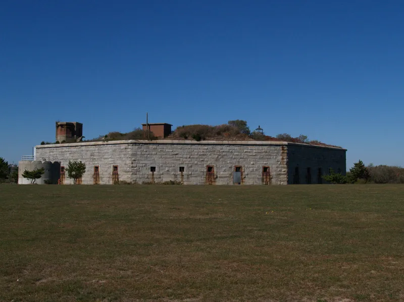
Clark's Point in New Bedford holds a coastal defense district made up of Fort Taber and five gun batteries. The fort is a seven-sided, three-story structure of hand-cut granite with a five-sided interior court, seaward gun embrasures of the Totten class, and a single landward sally-port entrance. Construction began in May 1861 after the federal government bought the land in 1858. Major Richard Delafield drew the initial designs, assisted by Captain Robert E. Lee, and Colonel Henry Martyn Roberts supervised the work. The Great Stone Fleet assembled under its guns in 1861. After years of vacancy the fort served as Marine Park from 1892, then was regarrisoned in 1898, when five reinforced-concrete batteries were added through 1901. It was declared obsolete in 1947 and later served as a training center and Job Corps site. At the time of listing, New Bedford was acquiring the property for a military museum and park.
Significance in brief: The nomination presents the district as representative of American coastal fortification from the Revolutionary period through the mid-20th century. Fort Taber is a Civil War-era northeastern fort in a remarkable state of preservation, with Totten-class embrasures believed to be the only example in New England. It is also tied to the Great Stone Fleet of 1861 and to figures such as Richard Delafield and Henry Martyn Roberts.
Machine-generated summary. This summary was generated by a language model from the official nomination document and has not been reviewed line by line by an editor. It may contain errors. Check the source document before relying on any detail. Source: nomination document (PDF) · National Archives catalog entry. NRHP reference 73001954, listed February 8, 1973. Summary generated October 2026 (model claude-sonnet-5-5, prompt v1.0-2026-10-29, confidence medium).
Key facts
| Address | Wharf Rd. within Fort Rodman Military Reservation, New Bedford |
|---|---|
| County | Bristol County |
| Listed | February 8, 1973 |
| Reference number | 73001954 |
| Resource type | District |
| Architect / builder | Designed by Major Richard Delafield, assisted by Captain Robert E. Lee; construction supervised by Colonel Henry Martyn Roberts |
| Areas of significance | Industry, Commerce |
| Level of significance | Local |
| Status (as stated in the nomination) | Condition listed as good and unaltered; the fort remains in good repair. It was being rehabilitated for park and museum use, with the City of New Bedford acquiring it from the federal government. |
| Acreage | 10.9 |
| Coordinates | 41.59291, -70.90092 (NPS GIS) |
What listing means for this property
This is a historic district. Buildings within its boundary are either contributing (they add to the district's significance) or non-contributing. Owners of contributing income-producing buildings can claim the 20% federal rehabilitation tax credit; homeowners should look at state credits. National Register districts impose no design review by themselves; a local historic district ordinance, if one exists, does (the difference explained).
General information, not legal or tax advice. Rules change; confirm with your State Historic Preservation Office or a qualified adviser.
Sources and further reading
- National Park Service, National Register of Historic Places database (snapshot May 2026), reference 73001954.
- Nomination form (PDF, National Archives) — catalog entry
- Wikipedia article (used for cross-checking only; text not reproduced here)
- Wikidata Q5472161
- This listing as JSON
Last updated October 2026. Found an error? See the editorial policy for how to report it.