Codding Farm, The
Also known as: Abiel Codding Farm; Titus Farm

Why it's listed
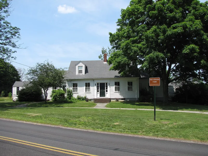
Codding Farm occupies the north side of High Street about half a mile west of North Attleborough center. The nominated core covers about 3.78 acres of a historic farm that once ran roughly 58 acres north to West Street. It includes a 1½-story, center-chimney Cape Cod farmhouse dating to about 1833, flanked by two one-story ells and an attached shed, along with an equipment shed, a side-gabled barn, fieldstone walls and two hay fields. The linked buildings form a nearly symmetrical variant of the connected farmstead type, and the trim shows early Greek Revival detailing. Abiel Codding Jr., a jewelry manufacturer who bought the farm for his parents, rose to a leading position in the town's jewelry industry, and the property stayed in family hands afterward. From 1881 it was worked by tenants for nearly a century. A railroad corridor and cattle pass cross its eastern edge, and the farm remains one of the largest open parcels near the town center.
Significance in brief: The farm is the closest large undeveloped land to North Attleborough center and preserves a fairly unusual symmetrical 'connected farmstead' of Federal/Greek Revival character. It is also tied to Abiel Codding Jr., a leading jewelry manufacturer, and later to nearly a century of tenant farming under Codding descendants.
Machine-generated summary. This summary was generated by a language model from the official nomination document and has not been reviewed line by line by an editor. It may contain errors. Check the source document before relying on any detail. Source: nomination document (PDF) · National Archives catalog entry. NRHP reference 09000236, listed April 22, 2009. Summary generated October 2026 (model claude-sonnet-5-5, prompt v1.0-2026-10-29, confidence medium).
Key facts
| Address | 217 High St., North Attleborough |
|---|---|
| County | Bristol County |
| Listed | April 22, 2009 |
| Reference number | 09000236 |
| Resource type | Building |
| Architectural style | Mid-19th Century: Federal/Greek Revival |
| Areas of significance | Community Planning and Development, Agriculture, Architecture |
| Level of significance | Local |
| Status (as stated in the nomination) | Listed historic functions include agriculture and single dwelling; current functions are listed as agricultural fields, recreation, vacant (buildings) and work in progress. |
| Acreage | 3.8 |
| Coordinates | 41.98553, -71.34205 (NPS GIS) |
What listing means for this property
National Register listing is honorary for a privately owned home: it does not by itself restrict what an owner may do with their own money, and it does not require public access. Restrictions come from local landmark or historic-district ordinances, which are separate (how they differ).
Owner-occupied houses are not eligible for the 20% federal rehabilitation tax credit, which applies to income-producing buildings, but many states offer credits for homeowners. Listing also opens the door to preservation easements and to buying a plaque. Start with what listing means for homeowners, renovating a listed house and selling one.
General information, not legal or tax advice. Rules change; confirm with your State Historic Preservation Office or a qualified adviser.
Sources and further reading
- National Park Service, National Register of Historic Places database (snapshot May 2026), reference 09000236.
- Nomination form (PDF, National Archives) — catalog entry
- Wikipedia article (used for cross-checking only; text not reproduced here)
- Wikidata Q16901521
- This listing as JSON
Last updated October 2026. Found an error? See the editorial policy for how to report it.