Illinois Waterway Project Office
Why it's listed
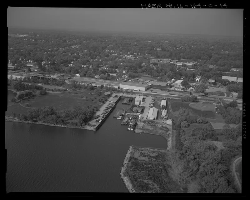
Along the Illinois River in a light industrial part of Peoria, this Army Corps of Engineers complex has serviced the boats and barges that keep the waterway working since 1913. The district includes a marine ways, where metal flat cars on tracks haul vessels out of the water for dry-dock repairs, and a rectangular boat harbor cut into the shoreline. Floating equipment includes Derrick Boat No. 3, the work barge Atlas, and the push boat Pekin. Plain metal-sheathed buildings hold storage, carpentry, painting and vehicle space, and a long brick garage dates from the 1930s. Newer additions, such as a 1992 office building, are counted as noncontributing. The complex was listed for its part in the maritime, transportation and industrial history of the Illinois Waterway, supporting the lock and dam system. Most surviving historic fabric comes from improvements made in 1928 and 1931-32.
Significance in brief: The district is significant under Criterion A for its role in maintaining and operating the Illinois Waterway's lock and dam facilities. The Corps founded the boatyard and marine ways in 1913 to service its fleet, and the facility was developed further in the 1920s and 1930s. Most of the historic fabric dates from improvements made in 1928 and 1931-32.
Machine-generated summary. This summary was generated by a language model from the official nomination document and has not been reviewed line by line by an editor. It may contain errors. Check the source document before relying on any detail. Source: nomination document (PDF) · National Archives catalog entry. NRHP reference 04000168, listed March 10, 2004. Summary generated October 2026 (model claude-sonnet-5-5, prompt v1.0-2026-10-29, confidence high).
Key facts
| Address | 257 Grant St., Peoria |
|---|---|
| County | Peoria County |
| Listed | March 10, 2004 |
| Reference number | 04000168 |
| Resource type | District |
| Period of significance | 1913-52 |
| Architect / builder | U.S. Army Corps of Engineers |
| Architectural style | No style |
| Criteria |
|
| Areas of significance | Maritime History, Transportation |
| Level of significance | National |
| Status (as stated in the nomination) | Still used for water-related transportation. The original harbor bulkhead installed in 1928 has been replaced, and newer buildings and boats have been added. |
| Acreage | 10 |
| Coordinates | 40.70416, -89.56583 (NPS GIS) |
What listing means for this property
This is a historic district. Buildings within its boundary are either contributing (they add to the district's significance) or non-contributing. Owners of contributing income-producing buildings can claim the 20% federal rehabilitation tax credit; homeowners should look at state credits. National Register districts impose no design review by themselves; a local historic district ordinance, if one exists, does (the difference explained).
General information, not legal or tax advice. Rules change; confirm with your State Historic Preservation Office or a qualified adviser.
Sources and further reading
- National Park Service, National Register of Historic Places database (snapshot May 2026), reference 04000168.
- Nomination form (PDF, National Archives) — catalog entry
- Wikipedia article (used for cross-checking only; text not reproduced here)
- Wikidata Q22059004
- This listing as JSON
Last updated October 2026. Found an error? See the editorial policy for how to report it.