Old Stone Arch, National Road

Why it's listed
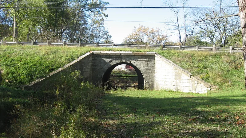
A limestone arch bridge on Archer Street near Marshall, Illinois, carries traffic over a 15-foot span with a height of 13.5 feet and a width of 50 feet. Army Engineers built it between 1828 and 1837 as part of the Old National Road, which began as the Cumberland Road and ran toward St. Louis. The stone was reportedly quarried in Indiana, floated down the Wabash River on a raft, and hauled to the site by ox cart. The stones were cut to fit and laid without bond, with keys cut in to prevent slippage. Four large wingwalls flank the arch. Mortar added to some joints in the 1930s and concrete placed at the downstream wingwall footings to stop scouring have not changed its basic original state. The bridge served all U.S. Route 40 traffic until 1953 and still handles roughly 1,300 vehicles daily. It was listed for its longevity, continuous use, and engineering.
Significance in brief: The nomination argues the bridge is significant for its longevity and continuous use, and as an excellent example of competent engineering and reliable masonry arch construction. It is one of the few remaining vestiges of the original National Road construction in Clark County. It carried all U.S. Route 40 traffic until fall 1953.
Machine-generated summary. This summary was generated by a language model from the official nomination document and has not been reviewed line by line by an editor. It may contain errors. Check the source document before relying on any detail. Source: nomination document (PDF) · National Archives catalog entry. NRHP reference 75000643, listed February 20, 1975. Summary generated October 2026 (model claude-sonnet-5-5, prompt v1.0-2026-10-29, confidence medium).
Key facts
| Address | Archer St., Marshall |
|---|---|
| County | Clark County |
| Listed | February 20, 1975 |
| Reference number | 75000643 |
| Resource type | Structure |
| Period of significance | Between 1828 and 1837 (19th Century) |
| Architect / builder | Army Engineers (Corps of Army Engineers); individual builder unknown |
| Areas of significance | Engineering, Transportation |
| Level of significance | National, State, Local |
| Status (as stated in the nomination) | In good condition and still in use as a connection from U.S. Route 40 to Marshall, carrying about 1,300 vehicles per day; basic structure in original state. |
| Acreage | 0.5 |
| Coordinates | 39.38700, -87.70834 (NPS GIS) |
What listing means for this property
National Register listing is honorary: it recognises significance and does not restrict what a private owner may do without federal money or permits. It unlocks the 20% federal rehabilitation tax credit for income-producing buildings, state credits in many states, and Section 106 review when federal agencies are involved. See what listing means in practice.
General information, not legal or tax advice. Rules change; confirm with your State Historic Preservation Office or a qualified adviser.
Sources and further reading
- National Park Service, National Register of Historic Places database (snapshot May 2026), reference 75000643.
- Nomination form (PDF, National Archives) — catalog entry
- Wikipedia article (used for cross-checking only; text not reproduced here)
- Wikidata Q16896160
- This listing as JSON
Last updated October 2026. Found an error? See the editorial policy for how to report it.