City Cemetery
Also known as: Old City Cemetery

Why it's listed
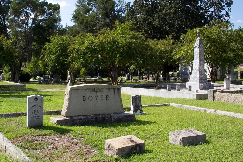
Old City Cemetery occupies five and a half acres west of downtown Sandersville, Georgia, bounded by Virginia Avenue, West Church Street and Haynes Street. Founded in 1836 and enlarged to its present size in 1868, it is divided into about 240 lots along a grid of alleys. Roughly half of the burials are marked by flat stone slabs, while others carry draped urns, obelisks, allegorical female figures, child memorials and a marble-faced family mausoleum. Two monuments are signed by the Macon firm of T.B. Artope, and a life-size cast metal statue for Ernestine Artman Roberts came from the Monumental Bronze Company of Bridgeport, Connecticut. Ten plots have ornamental iron fences, including two ante-bellum cast-iron examples. A plain granite block marks a World War I officer killed in the Meuse-Argonne battle. The collection was judged the most substantial of its kind in Washington County. Unmarked graves in the oldest section may also hold information about 19th-century burial customs.
Significance in brief: The cemetery holds the largest and most impressive collection of historic funerary sculpture in the city and county, showing the development of 19th and 20th century memorial art. It also has potential to yield information on 19th-century burial practices, especially from unmarked graves in its earliest section.
Machine-generated summary. This summary was generated by a language model from the official nomination document and has not been reviewed line by line by an editor. It may contain errors. Check the source document before relying on any detail. Source: nomination document (PDF) · National Archives catalog entry. NRHP reference 87001296, listed August 3, 1987. Summary generated October 2026 (model claude-sonnet-5-5, prompt v1.0-2026-10-29, confidence high).
Key facts
| Address | W. Church, Cemetery, and Haynes Sts., Sandersville |
|---|---|
| County | Washington County |
| Listed | August 3, 1987 |
| Reference number | 87001296 |
| Resource type | Site |
| Period of significance | 1836-1936 |
| Architect / builder | several |
| Criteria |
|
| Areas of significance | Historic - Non-Aboriginal, Art |
| Level of significance | Local |
| Status (as stated in the nomination) | Occupied and in use as a burial site; one ornamental iron fence was recently restored. |
| Acreage | 5.5 |
| Coordinates | 32.98301, -82.81519 (NPS GIS) |
What listing means for this property
Sites (archaeological sites, battlefields, landscapes) are often listed with a restricted address to protect them from looting or disturbance. Listing is honorary for private owners; federal undertakings on or near the site go through Section 106 review, and state laws may protect burials and artefacts regardless of listing.
General information, not legal or tax advice. Rules change; confirm with your State Historic Preservation Office or a qualified adviser.
Sources and further reading
- National Park Service, National Register of Historic Places database (snapshot May 2026), reference 87001296.
- Nomination form (PDF, National Archives) — catalog entry
- Wikipedia article (used for cross-checking only; text not reproduced here)
- Wikidata Q5123057
- This listing as JSON
Last updated October 2026. Found an error? See the editorial policy for how to report it.