Lott Cemetery

Why it's listed
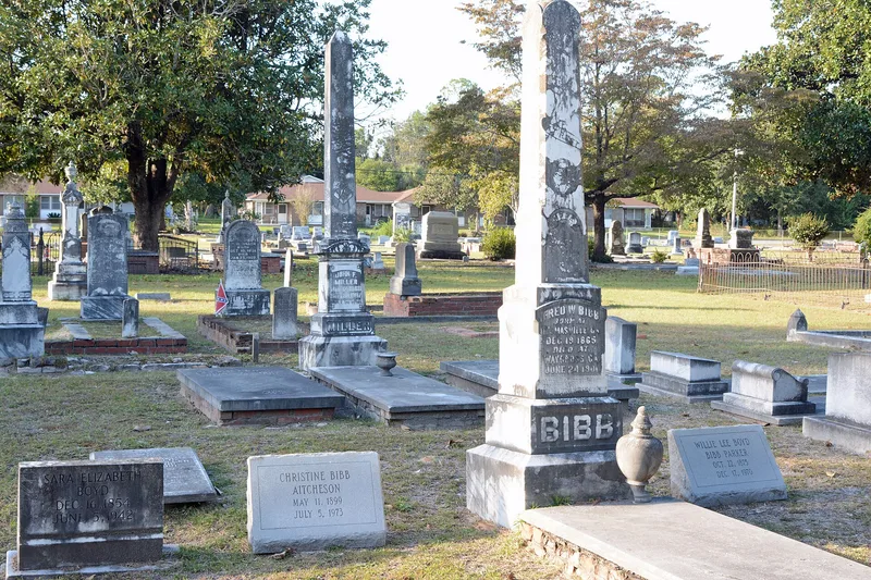
Lott Cemetery occupies a full city block of just over five acres northeast of downtown Waycross, Georgia, bounded by Butler, Tebeau, Quarterman and Pendleton streets. The earliest burial dates to 1877, and the city acquired the ground in 1889. Land for the cemetery came from Dr. Daniel Lott, one of the town's four founders, and the grounds served as the main burial place in Waycross until two other city cemeteries opened in 1901 and 1907. Laid out on a grid with grass driveways, brick, stone or concrete coping around plots, and cedar, magnolia and pecan trees, it reflects a late 19th-century park-like cemetery design. Markers include slabs, obelisks, truncated columns, angels and statuary, and six family plots have ornate iron fences. Over 1,700 burials are recorded, along with unmarked graves and a potter's field area. Founders William S. Bailey, Benjamin F. Williams and Dr. Lott are buried here. The cemetery remains in use.
Significance in brief: The nomination argues the cemetery is significant for its late 19th- and 20th-century funerary art and ornamental iron fencing, its link to the founding and growth of Waycross, and its park-like grid plan with coping-outlined plots and ornamental trees and shrubs. Many of the town's founders and civic leaders are buried there.
Machine-generated summary. This summary was generated by a language model from the official nomination document and has not been reviewed line by line by an editor. It may contain errors. Check the source document before relying on any detail. Source: nomination document (PDF) · National Archives catalog entry. NRHP reference 08000712, listed July 24, 2008. Summary generated October 2026 (model claude-sonnet-5-5, prompt v1.0-2026-10-29, confidence high).
Key facts
| Address | Butler St. between Tebeau and Pendleton St., Waycross |
|---|---|
| County | Ware County |
| Listed | July 24, 2008 |
| Reference number | 08000712 |
| Resource type | Site |
| Period of significance | 1877-1958 |
| Criteria |
|
| Areas of significance | Art, Community Planning and Development, Landscape Architecture |
| Level of significance | Local |
| Status (as stated in the nomination) | The cemetery is still in use, and the nomination says it retains a high degree of historic integrity, though some markers are in poor condition. |
| Acreage | 5.3 |
| Coordinates | 31.22238, -82.35469 (NPS GIS) |
What listing means for this property
Sites (archaeological sites, battlefields, landscapes) are often listed with a restricted address to protect them from looting or disturbance. Listing is honorary for private owners; federal undertakings on or near the site go through Section 106 review, and state laws may protect burials and artefacts regardless of listing.
General information, not legal or tax advice. Rules change; confirm with your State Historic Preservation Office or a qualified adviser.
Sources and further reading
- National Park Service, National Register of Historic Places database (snapshot May 2026), reference 08000712.
- Nomination form (PDF, National Archives) — catalog entry
- Wikipedia article (used for cross-checking only; text not reproduced here)
- Wikidata Q22058904
- This listing as JSON
Last updated October 2026. Found an error? See the editorial policy for how to report it.