Westside Historic District
Also known as: LaRoza Heights

Why it's listed
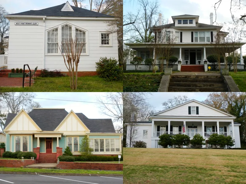
Westside Historic District is a hilly residential neighborhood in West Point, Georgia, just north of downtown and between the Alabama state line and the Chattahoochee River. Its streets continue the downtown grid, and its 92 contributing resources include houses, a cemetery with burials from 1841, and landmarks such as the Woman's Club, the Presbyterian Church and the Love Union Church. The earliest houses, found near West 10th Street and 2nd Avenue, are Greek Revival and date from about 1850. Queen Anne houses followed in the late 1800s, and the northern part filled in during the early 1900s with bungalows, cottages and the planned 1920s LaRoza Heights subdivision. Mid-century small houses and early ranch houses complete the sequence. The neighborhood grew with the railroads and the textile industry, and several of its grandest homes were built by members of the Lanier family, leaders of the West Point Manufacturing Company. Fort Tyler, site of a Civil War battle, lies at its western edge.
Significance in brief: The district shows how West Point's residential neighborhood grew over a century, from the 1850s through the mid-20th century, alongside the railroads and textile industry. It contains a wide range of Georgia house types and styles, and several of its larger houses were built by families tied to the West Point Manufacturing Company. The form also notes the history of African-American occupancy and a nearby Civil War battle site at Fort Tyler.
Machine-generated summary. This summary was generated by a language model from the official nomination document and has not been reviewed line by line by an editor. It may contain errors. Check the source document before relying on any detail. Source: nomination document (PDF) · National Archives catalog entry. NRHP reference 11000264, listed May 11, 2011. Summary generated October 2026 (model claude-sonnet-5-5, prompt v1.0-2026-10-29, confidence medium).
Key facts
| Address | Roughly bounded by W. 10th St., the GA-AL state line, W. 15th St. & the Chattahoochee R., West Point |
|---|---|
| County | Troup County |
| Listed | May 11, 2011 |
| Reference number | 11000264 |
| Resource type | District |
| Architect / builder | James William Melton (local builder, probably built 615 West 10th Street); William Turner (believed designer and builder of 1403 West 14th Street) |
| Architectural style | Greek Revival, Queen Anne, Colonial Revival, Tudor Revival, Bungalow/Craftsman, International Style |
| Areas of significance | Architecture, Community Planning and Development |
| Level of significance | Local |
| Status (as stated in the nomination) | Still largely in residential use, with a cemetery, churches, a clubhouse and some commercial development along 3rd Avenue and West 10th Street. |
| Coordinates | 32.88162, -85.18304 (NPS GIS) |
What listing means for this property
This is a historic district. Buildings within its boundary are either contributing (they add to the district's significance) or non-contributing. Owners of contributing income-producing buildings can claim the 20% federal rehabilitation tax credit; homeowners should look at state credits. National Register districts impose no design review by themselves; a local historic district ordinance, if one exists, does (the difference explained).
General information, not legal or tax advice. Rules change; confirm with your State Historic Preservation Office or a qualified adviser.
Sources and further reading
- National Park Service, National Register of Historic Places database (snapshot May 2026), reference 11000264.
- Nomination form (PDF, National Archives) — catalog entry
- Wikidata Q141810684
- This listing as JSON
Last updated October 2026. Found an error? See the editorial policy for how to report it.