Savannah Historic District

Why it's listed
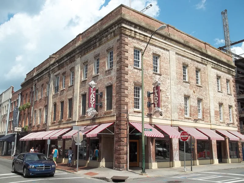
Savannah's historic district covers about two square miles of the city's original core, running from the Savannah River south to Gwinnett Street and between East and West Broad Streets. It holds roughly 1,100 noteworthy buildings, among them houses, commercial buildings, churches, the Customhouse, city hall and Telfair Academy. What sets it apart is its plan. James Edward Oglethorpe laid the city out in 1733 as wards, each centered on an open square and flanked by reserved lots for public buildings and blocks of ten house lots. By 1735 there were six wards, and growth followed this scheme into the mid-19th century. All six of the original squares survive. The buildings span Georgian, Greek Revival, Italianate, Gothic Revival, Victorian and early 20th-century Beaux-Arts and Colonial Revival work. Notable features include masonry row houses, the Factors Walk riverfront warehouses with iron bridges, and the Broughton Street shopping area. The unusual urban design and the architectural variety are the main reasons for its recognition.
Significance in brief: Savannah is unusual for its physical plan, an innovation in urban design by James Edward Oglethorpe, who laid it out in 1733 as wards built around open squares with house lots and reserved trustee lots. The city kept developing according to this plan through the middle of the 19th century. The district also holds a wide range of architecture from Georgian to early 20th-century styles.
Machine-generated summary. This summary was generated by a language model from the official nomination document and has not been reviewed line by line by an editor. It may contain errors. Check the source document before relying on any detail. Source: nomination document (PDF). NRHP reference 66000277, listed November 13, 1966. Summary generated October 2026 (model claude-sonnet-5-5, prompt v1.0-2026-10-29, confidence medium).
Key facts
| Address | Bounded by E. Broad, Gwinnett, and W. Broad Sts. and the Savannah River, Savannah |
|---|---|
| County | Chatham County |
| Listed | November 13, 1966 |
| Reference number | 66000277 |
| Resource type | District |
| Period of significance | 18th, 19th and 20th centuries |
| Architect / builder | James Edward Oglethorpe (town plan); many architects named in the supplementary text, including Charles B. Cluskey, John Norris, William Gibbons Preston and Hyman W. Witcover |
| Architectural style | Georgian, Federal, English Regency, Greek Revival, Italianate, Gothic Revival, Victorian and Revival styles, and row houses |
| Areas of significance | Community Planning and Development, Architecture |
| Level of significance | National |
| National Historic Landmark | Yes, designated November 13, 1966 |
| Status (as stated in the nomination) | Condition marked as good and integrity as altered; the district is occupied, with preservation work in progress. |
| Acreage | 525 |
| Coordinates | 32.07399, -81.09154 (NPS GIS) |
What listing means for this property
This is a historic district. Buildings within its boundary are either contributing (they add to the district's significance) or non-contributing. Owners of contributing income-producing buildings can claim the 20% federal rehabilitation tax credit; homeowners should look at state credits. National Register districts impose no design review by themselves; a local historic district ordinance, if one exists, does (the difference explained).
General information, not legal or tax advice. Rules change; confirm with your State Historic Preservation Office or a qualified adviser.
Sources and further reading
- National Park Service, National Register of Historic Places database (snapshot May 2026), reference 66000277.
- Nomination form (PDF, National Archives)
- Wikipedia article (used for cross-checking only; text not reproduced here)
- Wikidata Q3413304
- This listing as JSON
Last updated October 2026. Found an error? See the editorial policy for how to report it.