Sonoma Plaza
Also known as: Ol Sonoma; Sonoma Pueblo; See Also:Vallejo Estate

Why it's listed
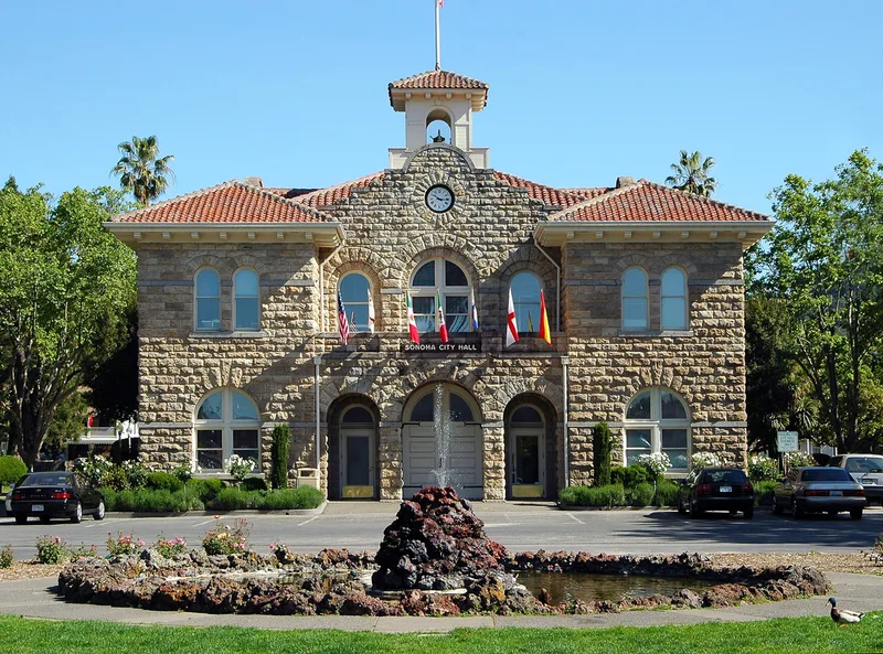
Sonoma Plaza is the historic core of Sonoma, California, built around an eight-acre plaza that General Mariano Vallejo laid out in 1835. Sonoma Pueblo served as the chief Mexican military base in Alta California, established partly to check Russian expansion from Fort Ross. On June 14, 1846, the Bear Flag was raised on the plaza, and on July 9 the American flag replaced it. Eleven one- and two-story Spanish-Mexican adobes still stand around or near the plaza, among them the Sonoma Barracks, Mission San Francisco Solano de Sonoma, the Blue Wing Inn and the Salvador Vallejo Adobe. Victorian and more modern buildings are mixed among them. The plaza is now a city park with City Hall at its center. Several adobes are part of Sonoma State Historic Park and open to visitors, while others are privately owned and house shops, restaurants and homes. The area is described as relatively unaltered, conveying historical integrity and atmosphere.
Significance in brief: The district marks the site of Sonoma Pueblo, the chief Mexican military base in Alta California from 1835 to the end of the Mexican period. It was the site where the Bear Flag was raised on June 14, 1846. Eleven Spanish-Mexican adobes survive near the plaza, which retains historical integrity and atmosphere. The document does not list formal criteria.
Machine-generated summary. This summary was generated by a language model from the official nomination document and has not been reviewed line by line by an editor. It may contain errors. Check the source document before relying on any detail. Source: nomination document (PDF) · National Archives catalog entry. NRHP reference 75000489, listed April 3, 1975. Summary generated October 2026 (model claude-sonnet-5-5, prompt v1.0-2026-10-29, confidence medium).
Key facts
| Address | Center of Sonoma, Sonoma |
|---|---|
| County | Sonoma County |
| Listed | April 3, 1975 |
| Reference number | 75000489 |
| Resource type | District |
| Architect / builder | General Mariano G. Vallejo (founder, plaza and Sonoma Barracks); Captain Salvador Vallejo (Swiss Hotel, Salvador Vallejo Adobe); Antonio Ortega (Blue Wing Inn); Jacob P. Leese (Leese-Fitch Adobe) |
| Architectural style | Monterey Colonial adobes, with Victorian Italianate, Classic Revival, Gothic Revival and Mission Revival buildings |
| Areas of significance | Military, Politics/Government, Architecture |
| Level of significance | National |
| National Historic Landmark | Yes, designated December 19, 1960 |
| Status (as stated in the nomination) | Condition marked good and relatively unaltered; the plaza is now a city park. Some adobes are state-owned and open to visitors as Sonoma State Historic Park, others are private and used as shops, restaurants and residences. |
| Acreage | 8 |
| Coordinates | 38.29352, -122.45429 (NPS GIS) |
What listing means for this property
This is a historic district. Buildings within its boundary are either contributing (they add to the district's significance) or non-contributing. Owners of contributing income-producing buildings can claim the 20% federal rehabilitation tax credit; homeowners should look at state credits. National Register districts impose no design review by themselves; a local historic district ordinance, if one exists, does (the difference explained).
General information, not legal or tax advice. Rules change; confirm with your State Historic Preservation Office or a qualified adviser.
Sources and further reading
- National Park Service, National Register of Historic Places database (snapshot May 2026), reference 75000489.
- Nomination form (PDF, National Archives) — catalog entry
- Wikipedia article (used for cross-checking only; text not reproduced here)
- Wikidata Q7562188
- This listing as JSON
Last updated October 2026. Found an error? See the editorial policy for how to report it.