Glen Canyon Covered Bridge
Also known as: Delaveaga Covered Bridge

Why it's listed
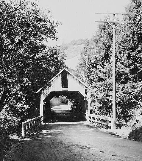
Spanning Branciforte Creek in DeLaveaga Park, this 83-foot wooden covered bridge was built in 1892 by contractor G.H. McKay on Glen Canyon Road to serve growing settlement north of Santa Cruz. Made of native redwood and Douglas fir, it uses a Howe truss, a simple modular design common in timber bridges across the country. The county condemned it in May 1939 because increased traffic called for a wider span. Local preservationists, volunteers and the WPA lifted it onto rollers and carts and moved it roughly half a mile upstream into the park, where it was rededicated in 1940. It is one of three covered bridges left in Santa Cruz County, and the nomination describes it as the southernmost in California and an early example of a community effort to save such a structure. The roof has been replaced, much of the siding has been lost, and a 1981 flood washed out its earlier foundation. Restoration plans are described but awaited funding.
Significance in brief: The nomination argues the bridge is significant for engineering and transportation as a typical Howe truss covered bridge. It is one of three surviving covered bridges in Santa Cruz County and is believed to be the southernmost covered bridge in California. It is also thought to be the first covered bridge in northern California moved as part of a community preservation effort.
Machine-generated summary. This summary was generated by a language model from the official nomination document and has not been reviewed line by line by an editor. It may contain errors. Check the source document before relying on any detail. Source: nomination document (PDF) · National Archives catalog entry. NRHP reference 84001194, listed May 17, 1984. Summary generated October 2026 (model claude-sonnet-5-5, prompt v1.0-2026-10-29, confidence medium).
Key facts
| Address | Branciforte Dr., Santa Cruz |
|---|---|
| County | Santa Cruz County |
| Listed | May 17, 1984 |
| Reference number | 84001194 |
| Resource type | Structure |
| Period of significance | 1800-1899 |
| Architect / builder | G.H. McKay, contractor |
| Architectural style | Howe truss covered bridge |
| Areas of significance | Transportation, Architecture |
| Level of significance | Local |
| Status (as stated in the nomination) | Listed as deteriorated and altered; a temporary mudsill foundation was installed after the 1981 flood, the siding is largely missing, and restoration awaits funding. It is now restricted to pedestrian use. |
| Acreage | 0.1 |
| Coordinates | 37.00009, -122.00320 (NPS GIS) |
What listing means for this property
For a publicly owned building or structure, listing mainly matters when federal funds, permits or licences are involved: projects then go through Section 106 review so effects on the property are considered. Listing also strengthens applications for preservation grants and, for leased income-producing uses, can enable the federal rehabilitation tax credit.
General information, not legal or tax advice. Rules change; confirm with your State Historic Preservation Office or a qualified adviser.
Sources and further reading
- National Park Service, National Register of Historic Places database (snapshot May 2026), reference 84001194.
- Nomination form (PDF, National Archives) — catalog entry
- Wikipedia article (used for cross-checking only; text not reproduced here)
- Wikidata Q58904032
- This listing as JSON
Last updated October 2026. Found an error? See the editorial policy for how to report it.