Point Bonita Light Station

Why it's listed
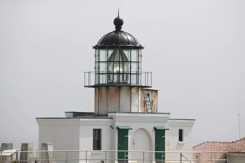
Point Bonita Light Station sits on narrow ledges blasted from rock at the tip of a promontory marking the northern entrance to San Francisco Bay. Established in 1855 after the Gold Rush filled the bay with shipping, the first lighthouse was built high on the hill but proved too high to be seen under the low fogs. In 1877 its iron tower and second-order Fresnel lens were moved to a new brick base at the water's edge, creating a hybrid design unique among California lighthouses. A brick fog-signal building followed in 1903, with decorative arched brickwork and fluted woodwork unusual for such structures. A 118-foot tunnel cut in 1876 and a 1954 pedestrian suspension bridge provide access. The station was automated in 1980, the last in California, and passed to the National Park Service in 1981. It was listed for its role in California maritime transportation and for its distinctive architecture.
Significance in brief: The station is significant under Criteria A and C for its link to California's reliance on maritime transportation and navigation aids. Its lighthouse combines an 1855 tower and lens with an 1877 brick base, a design unique among California lighthouses. The 1903 fog-signal building is notable for its decorative brickwork and woodwork. It is also the only lighthouse in the United States, and perhaps the world, approached by a suspension bridge.
Machine-generated summary. This summary was generated by a language model from the official nomination document and has not been reviewed line by line by an editor. It may contain errors. Check the source document before relying on any detail. Source: nomination document (PDF) · National Archives catalog entry. NRHP reference 91001099, listed September 3, 1991. Summary generated October 2026 (model claude-sonnet-5-5, prompt v1.0-2026-10-29, confidence high).
Key facts
| Address | Point Bonita, Sausalito |
|---|---|
| County | Marin County |
| Listed | September 3, 1991 |
| Reference number | 91001099 |
| Resource type | District |
| Period of significance | 1855-1940 |
| Architect / builder | Unknown |
| Architectural style | Other: lighthouse |
| Criteria |
|
| Areas of significance | Commerce, Transportation, Architecture, Maritime History |
| Level of significance | State |
| Status (as stated in the nomination) | Automated in 1980 and transferred to the National Park Service in 1981; opened for tours in 1984. The historic buildings are described as in very good condition, and the Coast Guard maintains modern navigation aids. |
| Acreage | 14 |
| Coordinates | 37.81837, -122.53053 (NPS GIS) |
What listing means for this property
This is a historic district. Buildings within its boundary are either contributing (they add to the district's significance) or non-contributing. Owners of contributing income-producing buildings can claim the 20% federal rehabilitation tax credit; homeowners should look at state credits. National Register districts impose no design review by themselves; a local historic district ordinance, if one exists, does (the difference explained).
General information, not legal or tax advice. Rules change; confirm with your State Historic Preservation Office or a qualified adviser.
Sources and further reading
- National Park Service, National Register of Historic Places database (snapshot May 2026), reference 91001099.
- Nomination form (PDF, National Archives) — catalog entry
- Wikipedia article (used for cross-checking only; text not reproduced here)
- Wikidata Q2100738
- This listing as JSON
Last updated October 2026. Found an error? See the editorial policy for how to report it.