Westmoreland State Park Historic District
Also known as: Westmoreland State Park; DHR Number 096-0089

Why it's listed
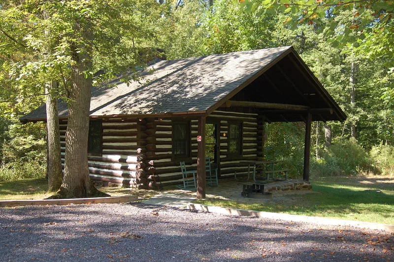
Westmoreland State Park occupies the Horsehead Cliffs and shoreline along the Potomac River in Westmoreland County, Virginia, next to Stratford Hall. The district holds 32 contributing and 26 noncontributing resources, including log and frame cabins, campgrounds, a restaurant building, picnic shelters, stone culverts, a fountain, a dam and water tower, hiking trails and a bulkheaded beach. Most of the historic fabric was built between 1933 and 1942 by Civilian Conservation Corps workers, who first built their own camp, a water system and maintenance shops before the roads, cabins and trails. The rustic cabins use hand-hewn logs, wide chinking and rough stone chimneys. The park entrance road, with its forested medians, follows National Park Service guidelines. The park was listed for its link to the Corps and to Virginia's early state park system, and for the preserved design of its plan and buildings. Later cabins from the 1950s and 1990s were added within the older layout.
Significance in brief: The nomination finds the district significant under Criteria A and C for its association with the Civilian Conservation Corps and the development of Virginia's state park system. It also cites the integrity of the park plan and its rustic buildings, which follow National Park Service design principles of the early 1930s.
Machine-generated summary. This summary was generated by a language model from the official nomination document and has not been reviewed line by line by an editor. It may contain errors. Check the source document before relying on any detail. Source: nomination document (PDF) · National Archives catalog entry. NRHP reference 05001265, listed November 16, 2005. Summary generated October 2026 (model claude-sonnet-5-5, prompt v1.0-2026-10-29, confidence medium).
Key facts
| Address | 1650 State Park Rd., Montross |
|---|---|
| County | Westmoreland County |
| Listed | November 16, 2005 |
| Reference number | 05001265 |
| Resource type | District |
| Period of significance | 1933-1942 |
| Architect / builder | E.L. Myers, Jr.; National Park Service; Virginia Commission on Conservation and Development; A. C. Barlow; Mattern and Mattern; CEGG Associates LC; Wiley and Wilson Inc.; other architects listed on a continuation sheet |
| Architectural style | Late 19th and Early 20th Century American Movements; Modern Movement |
| Criteria |
|
| Areas of significance | Architecture, Entertainment/Recreation, Landscape Architecture |
| Level of significance | State |
| Status (as stated in the nomination) | Still used as a state park with camping, cabins, trails and a beach. The former restaurant now serves as a meeting facility, and the CCC-era fountain and water filtration plant no longer operate. |
| Acreage | 1299 |
| Coordinates | 38.16551, -76.86655 (NPS GIS) |
What listing means for this property
This is a historic district. Buildings within its boundary are either contributing (they add to the district's significance) or non-contributing. Owners of contributing income-producing buildings can claim the 20% federal rehabilitation tax credit; homeowners should look at state credits. National Register districts impose no design review by themselves; a local historic district ordinance, if one exists, does (the difference explained).
General information, not legal or tax advice. Rules change; confirm with your State Historic Preservation Office or a qualified adviser.
Sources and further reading
- National Park Service, National Register of Historic Places database (snapshot May 2026), reference 05001265.
- Nomination form (PDF, National Archives) — catalog entry
- Wikidata Q98970742
- This listing as JSON
Last updated October 2026. Found an error? See the editorial policy for how to report it.