Four Mile Tree

Why it's listed
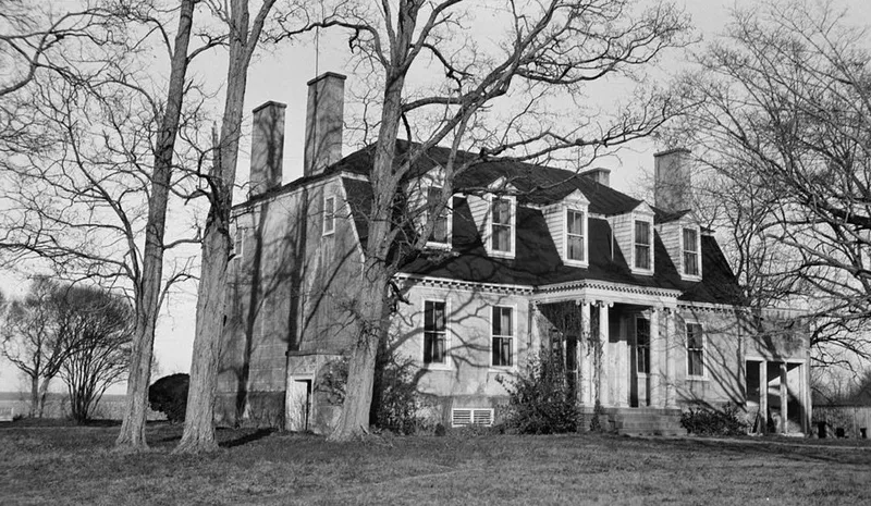
Four Mile Tree is a brick plantation house set on a bluff high above the James River, across from Jamestown Island in Surry County. The one-and-one-half-story building has a hip-on-gambrel roof, pedimented dormers and four interior end chimneys. Its brick is laid in Flemish bond above the watertable and English bond below, and was later stuccoed and scored to imitate stone. The oldest interior woodwork, in the central stair hall, dates to the first half of the eighteenth century. The plantation was founded in the first half of the seventeenth century as successor to the early Burrow's Hill and Pace's Paines plantations. It was the seat of the Browne family, who served as county justices, burgesses and militia officers, until the last male heir died in 1799. The grounds include the oldest legible tombstone in Virginia, dated 1650. Its uneven site and informal roofline give the house a picturesque quality, which a noted architectural author praised.
Significance in brief: The plantation succeeded two of Virginia's earliest plantations, Burrow's Hill and Pace's Paines, and was the seat of the Browne family, a leading Surry family, until 1799. Its grave-site holds what is described as the oldest legible tombstone in Virginia (1650). The house is also cited as an outstanding example of eighteenth-century Virginia building by master builders.
Machine-generated summary. This summary was generated by a language model from the official nomination document and has not been reviewed line by line by an editor. It may contain errors. Check the source document before relying on any detail. Source: nomination document (PDF) · National Archives catalog entry. NRHP reference 70000826, listed December 18, 1970. Summary generated October 2026 (model claude-sonnet-5-5, prompt v1.0-2026-10-29, confidence high).
Key facts
| Address | NE of the jct. of VA 618 and VA 610, Surry |
|---|---|
| County | Surry County |
| Listed | December 18, 1970 |
| Reference number | 70000826 |
| Resource type | Building |
| Architectural style | Eighteenth-century Virginia plantation house with later Revival-style alterations |
| Areas of significance | Architecture |
| Level of significance | State |
| Status (as stated in the nomination) | Listed in good condition, altered, on its original site, and occupied as a private residence; the stucco has deteriorated and fallen off in places. |
| Acreage | 250 |
| Coordinates | 37.20082, -76.85539 (NPS GIS) |
What listing means for this property
National Register listing is honorary: it recognises significance and does not restrict what a private owner may do without federal money or permits. It unlocks the 20% federal rehabilitation tax credit for income-producing buildings, state credits in many states, and Section 106 review when federal agencies are involved. See what listing means in practice.
General information, not legal or tax advice. Rules change; confirm with your State Historic Preservation Office or a qualified adviser.
Sources and further reading
- National Park Service, National Register of Historic Places database (snapshot May 2026), reference 70000826.
- Nomination form (PDF, National Archives) — catalog entry
- Wikipedia article (used for cross-checking only; text not reproduced here)
- Wikidata Q5475347
- This listing as JSON
Last updated October 2026. Found an error? See the editorial policy for how to report it.