Chippokes Plantation
Also known as: Chippokes Plantation Historic District; Chippokes; Chippokes S

Why it's listed
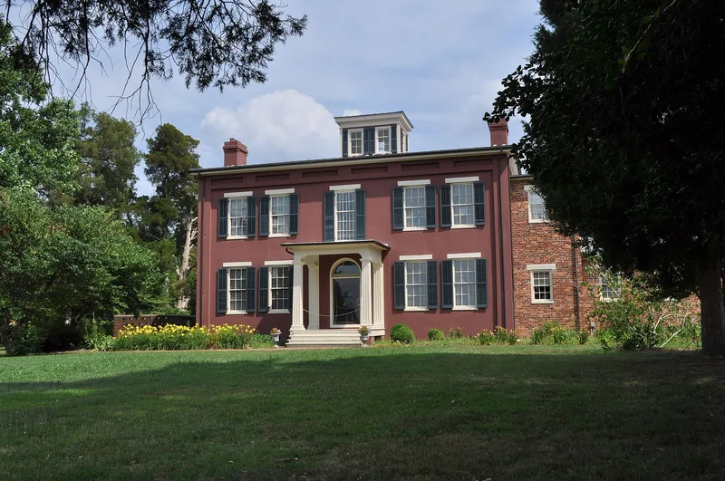
Chippokes Plantation is a 1,403-acre tract on the south bank of the James River in Surry County, Virginia, across from Jamestown Island. Bounded by College Run, Lower Chippokes Creek and Cobham Bay, it is now part of Chippokes State Park and still includes working pasture and cropland. The district holds thirty-seven buildings and structures, among them two unaltered plantation houses, one from about 1829-30 and one from about 1860, along with 19th-century outbuildings, slave quarters, and early-20th-century farm buildings and sharecroppers' dwellings. The plantation takes its name from a Native chief friendly to the English settlers. Its land was patented in the 1620s to Captain William Powell, later passed to Governor William Berkeley and then the Ludwell family, and was bought by new owners in 1837. Thirty-four identified archeological sites, four from the 17th century, may reveal early colonial life. The property was listed for its early settlement, its surviving 19th-century architecture, and its gardens and river views.
Significance in brief: The 1969 nomination argues the plantation is significant as one of the earliest in Virginia, with a land history running from the Virginia Company era through the Berkeley and Ludwell families. It also notes two fine early and mid-19th-century buildings, extensive gardens and river views. The 1986 documentation adds that thirty-four archeological sites, including four 17th-century ones, may illuminate early European colonization.
Machine-generated summary. This summary was generated by a language model from the official nomination document and has not been reviewed line by line by an editor. It may contain errors. Check the source document before relying on any detail. Source: nomination document (PDF) · National Archives catalog entry. NRHP reference 69000283, listed October 1, 1969. Summary generated October 2026 (model claude-sonnet-5-5, prompt v1.0-2026-10-29, confidence medium).
Key facts
| Address | Chippokes State Park, VA 634 and 633, Jamestown |
|---|---|
| County | Surry County |
| Listed | October 1, 1969 |
| Reference number | 69000283 |
| Resource type | District |
| Architectural style | Greek Revival and Italianate (main house and kitchen), with Colonial Revival outbuildings |
| Areas of significance | Prehistoric, Landscape Architecture, Historic - Non-Aboriginal, Exploration/Settlement, Architecture |
| Level of significance | State |
| Status (as stated in the nomination) | Operated as Chippokes State Park, with a working farm and a house museum; the 1969 form lists condition as good and the 1986 form as excellent and good. |
| Acreage | 1403 |
| Coordinates | 37.13973, -76.71464 (NPS GIS) |
What listing means for this property
This is a historic district. Buildings within its boundary are either contributing (they add to the district's significance) or non-contributing. Owners of contributing income-producing buildings can claim the 20% federal rehabilitation tax credit; homeowners should look at state credits. National Register districts impose no design review by themselves; a local historic district ordinance, if one exists, does (the difference explained).
General information, not legal or tax advice. Rules change; confirm with your State Historic Preservation Office or a qualified adviser.
Sources and further reading
- National Park Service, National Register of Historic Places database (snapshot May 2026), reference 69000283.
- Nomination form (PDF, National Archives) — catalog entry
- Wikipedia article (used for cross-checking only; text not reproduced here)
- Wikidata Q5101713
- This listing as JSON
Last updated October 2026. Found an error? See the editorial policy for how to report it.