Ferry Farm Site
Also known as: Site of George Washington's Boyhood Home

Why it's listed
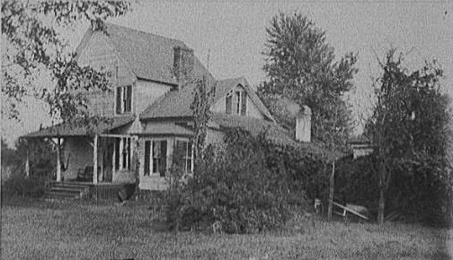
Ferry Farm is a 94-acre site on the bank of the Rappahannock River, overlooking Fredericksburg in Stafford County, Virginia. George Washington's father, Augustine, bought the farm in 1738, and George moved there shortly before his seventh birthday. He grew up on the property under the care of his widowed mother after his father died in 1743. The colonial farm has largely vanished. The main house was lost to fire, and only the old road to the ferry survives from that era. A tiny frame building traditionally called Washington's surveying office stands near the bluff, though most of its fabric is modern. Later buildings include a late nineteenth century farmhouse, a smokehouse and barns. Washington surveyed the land in 1771 and offered it for sale in 1772. The nomination values the site for its link to his formative years, for local legends such as the cherry tree story, and for its archaeological potential.
Significance in brief: The nomination argues that the site is significant as George Washington's boyhood home, where his family lived from 1738 and where he grew up under his widowed mother's care. The colonial buildings are gone, but the site has archaeological potential. It is described as one of Virginia's most important shrines.
Machine-generated summary. This summary was generated by a language model from the official nomination document and has not been reviewed line by line by an editor. It may contain errors. Check the source document before relying on any detail. Source: nomination document (PDF) · National Archives catalog entry. NRHP reference 72001417, listed May 5, 1972. Summary generated October 2026 (model claude-sonnet-5-5, prompt v1.0-2026-10-29, confidence medium).
Key facts
| Address | E of Fredericksburg at 712 Kings Hwy., Fredericksburg |
|---|---|
| County | Stafford County |
| Listed | May 5, 1972 |
| Reference number | 72001417 |
| Resource type | Site |
| Period of significance | 18th Century |
| Areas of significance | Social History |
| Level of significance | National |
| Status (as stated in the nomination) | Original acreage reduced to 94; colonial farm buildings gone except the old ferry road; a reputed surveying office, a late nineteenth century farmhouse and outbuildings remain. Condition marked fair and altered. |
| Acreage | 94 |
| Coordinates | 38.29342, -77.44840 (NPS GIS) |
What listing means for this property
Sites (archaeological sites, battlefields, landscapes) are often listed with a restricted address to protect them from looting or disturbance. Listing is honorary for private owners; federal undertakings on or near the site go through Section 106 review, and state laws may protect burials and artefacts regardless of listing.
General information, not legal or tax advice. Rules change; confirm with your State Historic Preservation Office or a qualified adviser.
Sources and further reading
- National Park Service, National Register of Historic Places database (snapshot May 2026), reference 72001417.
- Nomination form (PDF, National Archives) — catalog entry
- Wikipedia article (used for cross-checking only; text not reproduced here)
- Wikidata Q1408127
- This listing as JSON
Last updated October 2026. Found an error? See the editorial policy for how to report it.