Cabin Branch Pyrite Mine Historic District
Also known as: Dhr #076-0289

Why it's listed
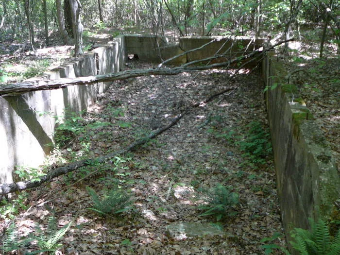
Pyrite, an ore used mainly to make sulfuric acid, was dug from this 88-acre site in what is now Prince William Forest Park between 1889 and 1920. The mine ran in two phases. The Cabin Branch Mining Company, owned by the Detrick and Bradley families, worked the eastern half until 1916, when the American Agricultural Chemical Corporation bought it, built new structures and sank at least one new shaft. Today the eastern side holds the concrete ruins of a commissary, a pony truss bridge, capped shafts and old tailings piles. The wooded western side holds foundations of the crusher house, mill, classifier house, concentrate bin, machine shop, engine room and boiler room, plus a reservoir and traces of rail routes now used as trails. Stone scatters probably mark housing for Black workers. The district was listed for its place in the region's mining industry and for what its remains can still reveal.
Significance in brief: The nomination argues the site is significant under Criteria A and D for its role in the pyrite mining industry, which supplied ore for sulfuric acid, and for its archeological potential. It documents two successive operations, one by the Cabin Branch Mining Company and one by the American Agricultural Chemical Corporation. It also reflects African-American and European-American ethnic heritage among the mine workers.
Machine-generated summary. This summary was generated by a language model from the official nomination document and has not been reviewed line by line by an editor. It may contain errors. Check the source document before relying on any detail. Source: nomination document (PDF) · National Archives catalog entry. NRHP reference 02001517, listed December 12, 2002. Summary generated October 2026 (model claude-sonnet-5-5, prompt v1.0-2026-10-29, confidence medium).
Key facts
| Address | Prince William Forest Park, Triangle |
|---|---|
| County | Prince William County |
| Listed | December 12, 2002 |
| Reference number | 02001517 |
| Resource type | District |
| Period of significance | 1889-1920 |
| Architectural style | No style |
| Criteria |
|
| Areas of significance | Industry, Historic - Aboriginal |
| Level of significance | State |
| Status (as stated in the nomination) | Now part of a public park; shafts were capped and stabilized in a 1995 reclamation project, and a boardwalk was added in 1999. Most structures survive only as foundations and ruins. |
| Acreage | 68 |
| Within district | Prince William Forest Park Historic District |
| Coordinates | 38.57678, -77.34905 (NPS GIS) |
What listing means for this property
This is a historic district. Buildings within its boundary are either contributing (they add to the district's significance) or non-contributing. Owners of contributing income-producing buildings can claim the 20% federal rehabilitation tax credit; homeowners should look at state credits. National Register districts impose no design review by themselves; a local historic district ordinance, if one exists, does (the difference explained).
General information, not legal or tax advice. Rules change; confirm with your State Historic Preservation Office or a qualified adviser.
Sources and further reading
- National Park Service, National Register of Historic Places database (snapshot May 2026), reference 02001517.
- Nomination form (PDF, National Archives) — catalog entry
- Wikipedia article (used for cross-checking only; text not reproduced here)
- Wikidata Q15206646
- This listing as JSON
Last updated October 2026. Found an error? See the editorial policy for how to report it.