Glebe of Hungar's Parish

Why it's listed
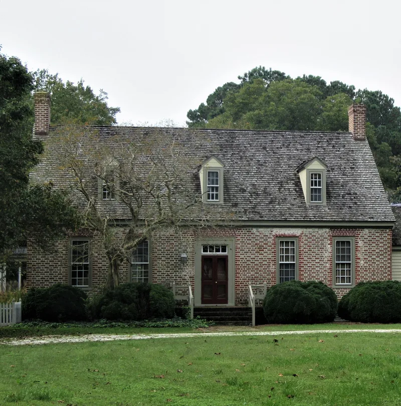
Near Franktown on Virginia's Eastern Shore, this brick glebe house sits on land Stephen Charlton patented in 1638 and expanded in 1641. His 1654 will directed that the land pass to the parish if his daughter died without heirs, and Hungar's Parish acquired it in 1704. The house rises one and a half stories under a gable roof with dormers and two interior end chimneys. Its brick is laid in Flemish bond with English bond below the water table, with extensive glazed headers and flat arches over the openings of the five-bay east front. A central stair hall is flanked by two rooms on each side, each with a corner chimney. The northwest room keeps its cornice, paneled dado and paneled chimney breast. The construction date is uncertain, placed between 1643 and 1745, and the house may incorporate Charlton's earlier dwelling. From 1745 until 1850 it was the official residence of the parish ministers.
Significance in brief: The house served as the official residence of the ministers of Hungar's Parish from 1745 until 1850. It is notable for its exceptionally fine brickwork and an almost complete room of eighteenth-century paneling. It may also incorporate Charlton's seventeenth-century dwelling.
Machine-generated summary. This summary was generated by a language model from the official nomination document and has not been reviewed line by line by an editor. It may contain errors. Check the source document before relying on any detail. Source: nomination document (PDF) · National Archives catalog entry. NRHP reference 70000817, listed February 26, 1970. Summary generated October 2026 (model claude-sonnet-5-5, prompt v1.0-2026-10-29, confidence medium).
Key facts
| Address | NW of jct. of Rtes. 622 and 619, Franktown |
|---|---|
| County | Northampton County |
| Listed | February 26, 1970 |
| Reference number | 70000817 |
| Resource type | Building |
| Areas of significance | Architecture, Religion |
| Level of significance | State |
| Status (as stated in the nomination) | Condition is marked as deteriorated, with preservation work in progress; current use is a private residence. |
| Acreage | 40.5 |
| Coordinates | 37.46023, -75.96180 (NPS GIS) |
What listing means for this property
Religious properties are listed for their architectural or historical significance, not their religious use. Listing is honorary and does not restrict the congregation's use of the building. The federal rehabilitation credit is generally unavailable unless part of the building is income-producing; some state programmes and preservation grants do cover religious buildings. Federal funding or permits trigger Section 106 review.
General information, not legal or tax advice. Rules change; confirm with your State Historic Preservation Office or a qualified adviser.
Sources and further reading
- National Park Service, National Register of Historic Places database (snapshot May 2026), reference 70000817.
- Nomination form (PDF, National Archives) — catalog entry
- Wikipedia article (used for cross-checking only; text not reproduced here)
- Wikidata Q15221740
- This listing as JSON
Last updated October 2026. Found an error? See the editorial policy for how to report it.