Custis Tombs
Also known as: Custis cemetery at Arlington

Why it's listed
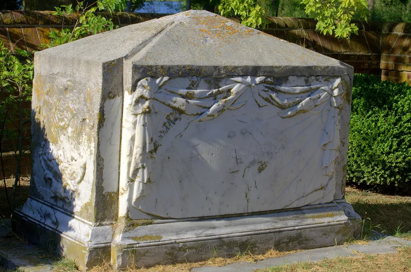
Two tombs mark what remains of the Custis family burial ground on the south bank of Old Plantation Creek, near Cheapside in Northampton County. A poured concrete platform and a high iron fence, set in a grove of trees, surround them. One is a limestone slab on a low brick base for Major General John Custis (1630-1696), who came to Virginia around 1650 and established his seat, Arlington, on the Eastern Shore. The other is the box-like marble tomb of his grandson John Custis IV, with a pyramidal top, drapery carving, a family crest and a skull set within a shield. It is signed by William Colley of London and is notably well preserved. The family's descendants include the wife of Robert E. Lee and Martha Washington's grandchildren, and the name Arlington later passed to the National Cemetery. The site is regarded as one of Virginia's most significant unexcavated colonial sites.
Significance in brief: The nomination calls it one of the most significant unexcavated colonial sites in Virginia, tied to the prominent Custis family and the original Arlington seat on the Eastern Shore. The marble tomb of John Custis IV is a finely carved, well-preserved and signed example of 18th-century funerary sculpture with a rare skull motif.
Machine-generated summary. This summary was generated by a language model from the official nomination document and has not been reviewed line by line by an editor. It may contain errors. Check the source document before relying on any detail. Source: nomination document (PDF) · National Archives catalog entry. NRHP reference 70000815, listed April 17, 1970. Summary generated October 2026 (model claude-sonnet-5-5, prompt v1.0-2026-10-29, confidence medium).
Key facts
| Address | NW of jct. of Rtes. 644 and 645, Cheapside |
|---|---|
| County | Northampton County |
| Listed | April 17, 1970 |
| Reference number | 70000815 |
| Resource type | Site |
| Architect / builder | William Colley of Fenchurch Street, London (maker of the John Custis IV tomb) |
| Areas of significance | Other |
| Level of significance | National |
| Status (as stated in the nomination) | Condition marked deteriorated; tombs unaltered and on original site; open to the public without restriction. |
| Acreage | 0.9 |
| Coordinates | 37.22902, -76.00355 (NPS GIS) |
What listing means for this property
Sites (archaeological sites, battlefields, landscapes) are often listed with a restricted address to protect them from looting or disturbance. Listing is honorary for private owners; federal undertakings on or near the site go through Section 106 review, and state laws may protect burials and artefacts regardless of listing.
General information, not legal or tax advice. Rules change; confirm with your State Historic Preservation Office or a qualified adviser.
Sources and further reading
- National Park Service, National Register of Historic Places database (snapshot May 2026), reference 70000815.
- Nomination form (PDF, National Archives) — catalog entry
- Wikipedia article (used for cross-checking only; text not reproduced here)
- Wikidata Q15212221
- This listing as JSON
Last updated October 2026. Found an error? See the editorial policy for how to report it.