Winona
Also known as: 122-0828

Why it's listed
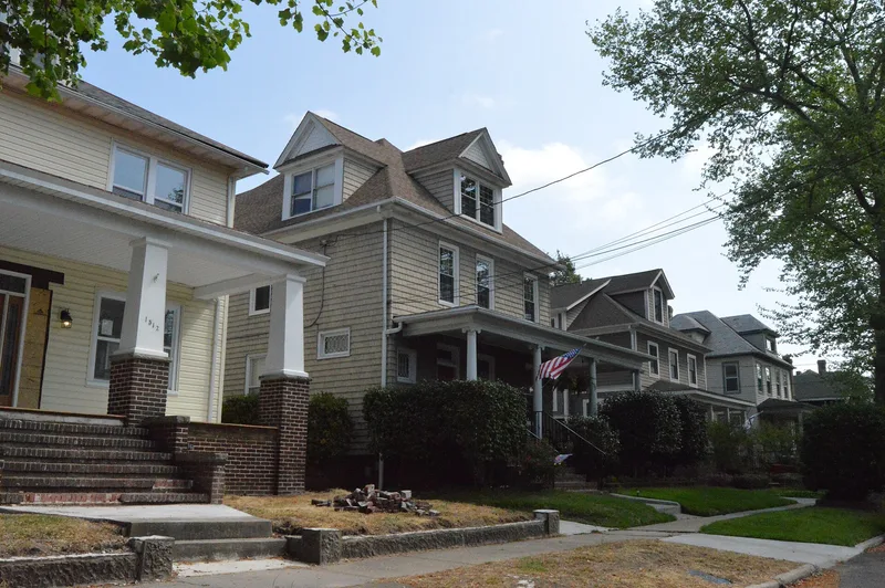
Winona is a small residential neighborhood on the east bank of the Lafayette River in Norfolk, Virginia. Platted in 1909 by the Leicht Real Estate Company, it was laid out with curving, tree-lined streets, small parks and waterfront lots, and offered paved roads, sidewalks, a concrete sea wall, utilities and streetcar access. About 24 houses went up between 1909 and 1915, mostly Colonial Revival, Queen Anne and Classical Revival homes for well-off buyers. A second wave from 1916 to 1941, driven by workers arriving at the port during the First World War, added about 117 buildings, many of them smaller Colonial Revival houses, Craftsman bungalows and four-squares. A few Spanish-inspired and Cape Cod houses also appear. The district holds 203 contributing resources. It was recognized as a planned suburb serving Norfolk's growing middle and upper classes, and for its mix of high-style and more modest early twentieth-century architecture.
Significance in brief: The nomination argues Winona is significant under Criterion A as a planned community that served Norfolk's growing middle- to upper-class suburban population in the early 20th century. It is significant under Criterion C for its concentration of high-style architecture and, as the market shifted, more modest, less ornate housing.
Machine-generated summary. This summary was generated by a language model from the official nomination document and has not been reviewed line by line by an editor. It may contain errors. Check the source document before relying on any detail. Source: nomination document (PDF) · National Archives catalog entry. NRHP reference 01000702, listed July 5, 2001. Summary generated October 2026 (model claude-sonnet-5-5, prompt v1.0-2026-10-29, confidence medium).
Key facts
| Address | Roughly bounded by Ashland Circle, Ashland Ave., Elmere Place, Huntington Crescent, Holland Ave., and the Lafayette, Norfolk (Independent City) |
|---|---|
| County | Norfolk |
| Listed | July 5, 2001 |
| Reference number | 01000702 |
| Resource type | District |
| Architect / builder | Jacob Leicht (original developer, who built 1419 Huntington Crescent); plan based on drawings by civil engineer C.F. Petree; most houses designed by local builders and architects |
| Architectural style | Late Victorian (Queen Anne, Shingle Style); Colonial Revival; Classical Revival; Mission/Spanish Colonial Revival; Bungalow/Craftsman |
| Criteria |
|
| Areas of significance | Architecture, Community Planning and Development |
| Level of significance | Local |
| Status (as stated in the nomination) | Still a residential neighborhood of single dwellings; a monument is also present. |
| Acreage | 31 |
| Coordinates | 36.88098, -76.26894 (NPS GIS) |
What listing means for this property
This is a historic district. Buildings within its boundary are either contributing (they add to the district's significance) or non-contributing. Owners of contributing income-producing buildings can claim the 20% federal rehabilitation tax credit; homeowners should look at state credits. National Register districts impose no design review by themselves; a local historic district ordinance, if one exists, does (the difference explained).
General information, not legal or tax advice. Rules change; confirm with your State Historic Preservation Office or a qualified adviser.
Sources and further reading
- National Park Service, National Register of Historic Places database (snapshot May 2026), reference 01000702.
- Nomination form (PDF, National Archives) — catalog entry
- Wikipedia article (used for cross-checking only; text not reproduced here)
- Wikidata Q16903546
- This listing as JSON
Last updated October 2026. Found an error? See the editorial policy for how to report it.