Colonial Place

Why it's listed
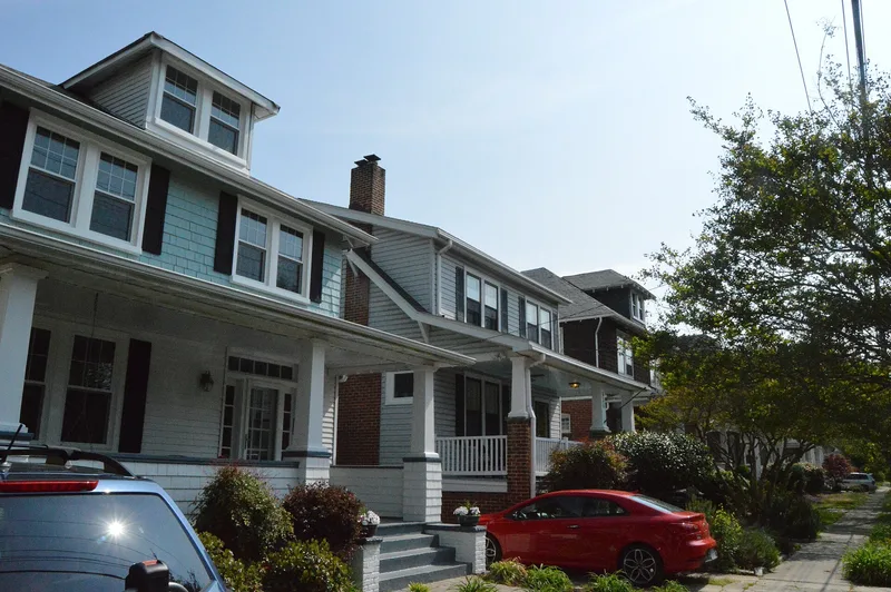
Colonial Place is a planned residential neighborhood in Norfolk, Virginia, set on a peninsula reaching into the Lafayette River. Platted in 1903 by the Sterling Place Company under George W. Dillard, it was laid out with curving streets, tree-lined sidewalks, traffic circles and four small parks. The 1907 Jamestown Exhibition inspired the colonial theme used for the subdivision's name and its streets. Early building was slow, with about nineteen houses by 1911, mostly Colonial Revival, Dutch Colonial Revival and Queen Anne. Wartime demand for housing brought roughly 750 more buildings between 1912 and 1941, and the neighborhood settled into a middle-class community. Craftsman bungalows dominate this later phase, with 393 examples. The district now contains about 913 single-family dwellings, 43 multiple-family dwellings, a school, a church and hundreds of garages and sheds. It was listed for its cohesive planning and its range of early 20th-century architecture.
Significance in brief: The nomination presents Colonial Place as a planned streetcar suburb with curvilinear streets, traffic circles and parks, shaped by picturesque and City Beautiful planning ideas and the 1907 Jamestown Exhibition's colonial theme. It also holds a large, well-preserved collection of early 20th-century house styles, from Colonial Revival and Queen Anne to Craftsman bungalows. Its growth from an upper-class venture into a middle-class neighborhood is documented through its buildings.
Machine-generated summary. This summary was generated by a language model from the official nomination document and has not been reviewed line by line by an editor. It may contain errors. Check the source document before relying on any detail. Source: nomination document (PDF) · National Archives catalog entry. NRHP reference 02000532, listed May 22, 2002. Summary generated October 2026 (model claude-sonnet-5-5, prompt v1.0-2026-10-29, confidence medium).
Key facts
| Address | Roughly bounded by the Lafayette R., Knitting Mill Creek, East Haven Creek and 38th St., Norfolk |
|---|---|
| County | Norfolk |
| Listed | May 22, 2002 |
| Reference number | 02000532 |
| Resource type | District |
| Architect / builder | George W. Dillard (developer, Sterling Place Company); builders include Walter Turpin, James Turpin, S.L. McGonigal and Charles C. Fitch |
| Architectural style | Late Victorian/Queen Anne; Colonial Revival and Dutch Colonial Revival; Mission/Spanish Colonial Revival; Tudor Revival; Bungalow/Craftsman; Art Deco |
| Areas of significance | Architecture, Community Planning and Development |
| Level of significance | Local |
| Status (as stated in the nomination) | Still largely in residential use, with single and multiple dwellings, a church, a school and four landscaped parks; many houses have been re-clad in aluminum, vinyl or asbestos siding. |
| Acreage | 202 |
| Coordinates | 36.88527, -76.28853 (NPS GIS) |
What listing means for this property
This is a historic district. Buildings within its boundary are either contributing (they add to the district's significance) or non-contributing. Owners of contributing income-producing buildings can claim the 20% federal rehabilitation tax credit; homeowners should look at state credits. National Register districts impose no design review by themselves; a local historic district ordinance, if one exists, does (the difference explained).
General information, not legal or tax advice. Rules change; confirm with your State Historic Preservation Office or a qualified adviser.
Sources and further reading
- National Park Service, National Register of Historic Places database (snapshot May 2026), reference 02000532.
- Nomination form (PDF, National Archives) — catalog entry
- Wikipedia article (used for cross-checking only; text not reproduced here)
- Wikidata Q5148358
- This listing as JSON
Last updated October 2026. Found an error? See the editorial policy for how to report it.