Lee's Mill Earthworks
Also known as: Mill Tract; 121-0050

Why it's listed
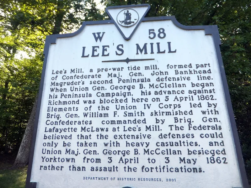
Rifle pits and a large redoubt survive in a wooded tract beside the Warwick River in Newport News, remnants of the Confederate defensive line built across the Virginia Peninsula in 1861 and 1862. Engineers Isaac St. John and Alfred Rives, serving under Maj. Gen. John Bankhead Magruder, laid out the works on bluffs above Richard D. Lee's gristmill, and soldiers and enslaved laborers dug them. The redoubt held two cannons, and its remains include a surrounding ditch, gun ramps, and depressions where bomb proofs and a magazine once stood. On April 5, 1862, Confederate defenders here stopped a Union advance under Brig. Gen. William Smith, delaying McClellan's march toward Richmond and prompting a siege of the line that lasted about three weeks. Today a trail and a Civil War Trails sign serve visitors, and housing and Fort Eustis border the site. The property was bought in 1995 to prevent its destruction by developers.
Significance in brief: The earthworks were a strong point in Maj. Gen. John B. Magruder's twelve-mile Warwick-Yorktown line. The April 5, 1862 Battle of Lee's Mill halted Union Maj. Gen. George McClellan's flanking maneuver and led to a three-week siege. The site is also linked to Confederate engineers Isaac St. John and Alfred Rives and is described as among the best surviving examples of the line.
Machine-generated summary. This summary was generated by a language model from the official nomination document and has not been reviewed line by line by an editor. It may contain errors. Check the source document before relying on any detail. Source: nomination document (PDF) · National Archives catalog entry. NRHP reference 03000568, listed June 23, 2003. Summary generated October 2026 (model claude-sonnet-5-5, prompt v1.0-2026-10-29, confidence high).
Key facts
| Address | 280 Rivers Ridge Cir., Newport News |
|---|---|
| County | Newport News |
| Listed | June 23, 2003 |
| Reference number | 03000568 |
| Resource type | Site |
| Period of significance | 1861-1862 |
| Architect / builder | Rives, Alfred; St. John, Isaac |
| Criteria |
|
| Areas of significance | Military |
| Level of significance | State |
| Status (as stated in the nomination) | Wooded public park with a walking trail, parking lot and interpretive sign; the earthworks survive under forest cover, though the powder magazine has collapsed and the bomb proofs are now depressions. |
| Acreage | 10 |
| Coordinates | 37.16733, -76.55318 (NPS GIS) |
What listing means for this property
Sites (archaeological sites, battlefields, landscapes) are often listed with a restricted address to protect them from looting or disturbance. Listing is honorary for private owners; federal undertakings on or near the site go through Section 106 review, and state laws may protect burials and artefacts regardless of listing.
General information, not legal or tax advice. Rules change; confirm with your State Historic Preservation Office or a qualified adviser.
Sources and further reading
- National Park Service, National Register of Historic Places database (snapshot May 2026), reference 03000568.
- Nomination form (PDF, National Archives) — catalog entry
- Wikipedia article (used for cross-checking only; text not reproduced here)
- Wikidata Q16894077
- This listing as JSON
Last updated October 2026. Found an error? See the editorial policy for how to report it.