Black Walnut
Also known as: DHR File No. 41-06
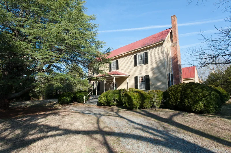

Why it's listed
Black Walnut is a Halifax County, Virginia, plantation near Clover that preserves buildings from the late eighteenth century to the early twentieth. The frame main house grew in stages: a small single-pile house built between about 1774 and 1790, a raised central section in the early nineteenth century, and a two-story front addition probably built in 1848 that gave the house an H shape. Around it are a brick kitchen, dairy, smokehouses, a schoolhouse, a privy, barns and a farmyard. One slave cabin survives, the last of almost thirty once on the property. A family cemetery, boxwood garden and terraced vegetable gardens remain. John Sims built the estate into 2,491 acres, and by 1852 his land holdings were exceeded in the county only by those of one other owner. The 1850 census recorded 60,000 pounds of tobacco alongside grain and livestock. The Sims family and their descendants have held the property, and the Battle of Staunton River Bridge in 1864 took place on its land.
Significance in brief: The nomination argues the property is an unusually complete and well-preserved large farm spanning the late eighteenth to early twentieth century. It was one of the largest and most prosperous farms in Halifax County in the nineteenth century, with a very large tobacco crop. It also illustrates the full range of plantation buildings and has architectural value.
Machine-generated summary. This summary was generated by a language model from the official nomination document and has not been reviewed line by line by an editor. It may contain errors. Check the source document before relying on any detail. Source: nomination document (PDF) · National Archives catalog entry. NRHP reference 91001597, listed October 29, 1991. Summary generated October 2026 (model claude-sonnet-5-5, prompt v1.0-2026-10-29, confidence high).
Key facts
| Address | VA 600, 850 ft. S of jct. with VA 778, Clover |
|---|---|
| County | Halifax County |
| Listed | October 29, 1991 |
| Reference number | 91001597 |
| Resource type | Building |
| Period of significance | ca. 1774-1928 |
| Architect / builder | unknown |
| Architectural style | Colonial: Georgian; Mid-19th Century: Greek Revival |
| Criteria |
|
| Areas of significance | Agriculture, Architecture |
| Level of significance | Local |
| Status (as stated in the nomination) | Still a family-owned farm; the house is described as having retained its character and integrity, with few alterations since the 1840s. |
| Acreage | 8 |
| Coordinates | 36.86315, -78.72234 (NPS GIS) |
What listing means for this property
National Register listing is honorary: it recognises significance and does not restrict what a private owner may do without federal money or permits. It unlocks the 20% federal rehabilitation tax credit for income-producing buildings, state credits in many states, and Section 106 review when federal agencies are involved. See what listing means in practice.
General information, not legal or tax advice. Rules change; confirm with your State Historic Preservation Office or a qualified adviser.
Sources and further reading
- National Park Service, National Register of Historic Places database (snapshot May 2026), reference 91001597.
- Nomination form (PDF, National Archives) — catalog entry
- Wikipedia article (used for cross-checking only; text not reproduced here)
- Wikidata Q14712032
- This listing as JSON
Last updated October 2026. Found an error? See the editorial policy for how to report it.