Crooked Run Valley Rural Historic District
Also known as: VDHR File No. 030-5369

Why it's listed
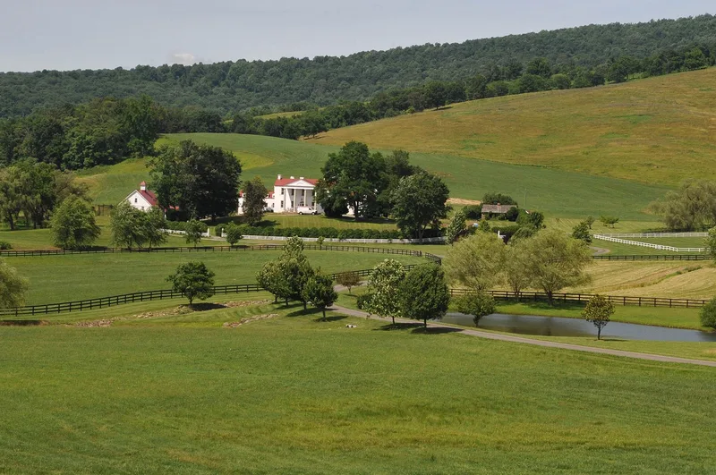
Crooked Run Valley is a rural historic district covering about 18,630 acres in the northwest corner of Fauquier County, Virginia, between the Blue Ridge foothills and the Goose Creek watershed. Route 17 runs through its center along an old Native American trade route. The district includes the villages of Paris and Delaplane, the settlement of Scuffleburg, and hundreds of farmhouses, tenant houses, barns, mills, churches and schools. Its earliest buildings date to the mid-1700s and are simple log, frame and stone vernacular structures, while later ones show Federal, Greek Revival, Gothic Revival and Victorian influences. Local fieldstone was widely used for houses, outbuildings and the fences that still divide pastures. Cattle and horse breeding and hay production have dominated farming. The district was recognized for preserving this landscape of farms, villages, roads and scenic vistas, which reflects the self-sufficient agricultural society that settled the valley over about 250 years. It also holds associations with Mosby's Rangers.
Significance in brief: The district preserves a farming landscape shaped over roughly 250 years, with fieldstone fences, historic roads, farm complexes and mountain views. Its resources reflect the themes of agriculture, education, religion, military history, transportation, industry and African-American heritage. The description also notes its association with Mosby's Rangers during the Civil War.
Machine-generated summary. This summary was generated by a language model from the official nomination document and has not been reviewed line by line by an editor. It may contain errors. Check the source document before relying on any detail. Source: nomination document (PDF) · National Archives catalog entry. NRHP reference 04000550, listed May 27, 2004. Summary generated October 2026 (model claude-sonnet-5-5, prompt v1.0-2026-10-29, confidence medium).
Key facts
| Address | Roughly boundey by Fauquier Cty Line, I-66, VA 712, Naked Mountain, and VA 55, Paris |
|---|---|
| County | Fauquier County |
| Listed | May 27, 2004 |
| Reference number | 04000550 |
| Resource type | District |
| Architectural style | Colonial, Early Republic (Federal), Greek Revival, Gothic Revival, Italianate, Queen Anne, Colonial Revival, Beaux Arts, Bungalow/Craftsman, and vernacular forms |
| Areas of significance | Agriculture, Architecture, Exploration/Settlement, Industry, Military, Transportation |
| Level of significance | Local |
| Status (as stated in the nomination) | Land is mostly used for farming or unused pasture; over 3,300 acres are in open-space easement or public ownership. The Delaplane rail line is still active. |
| Acreage | 18630 |
| Coordinates | 38.96830, -77.98053 (NPS GIS) |
What listing means for this property
This is a historic district. Buildings within its boundary are either contributing (they add to the district's significance) or non-contributing. Owners of contributing income-producing buildings can claim the 20% federal rehabilitation tax credit; homeowners should look at state credits. National Register districts impose no design review by themselves; a local historic district ordinance, if one exists, does (the difference explained).
General information, not legal or tax advice. Rules change; confirm with your State Historic Preservation Office or a qualified adviser.
Sources and further reading
- National Park Service, National Register of Historic Places database (snapshot May 2026), reference 04000550.
- Nomination form (PDF, National Archives) — catalog entry
- Wikipedia article (used for cross-checking only; text not reproduced here)
- Wikidata Q14712218
- This listing as JSON
Last updated October 2026. Found an error? See the editorial policy for how to report it.