Pleasant View
Also known as: Trabue's Tavern
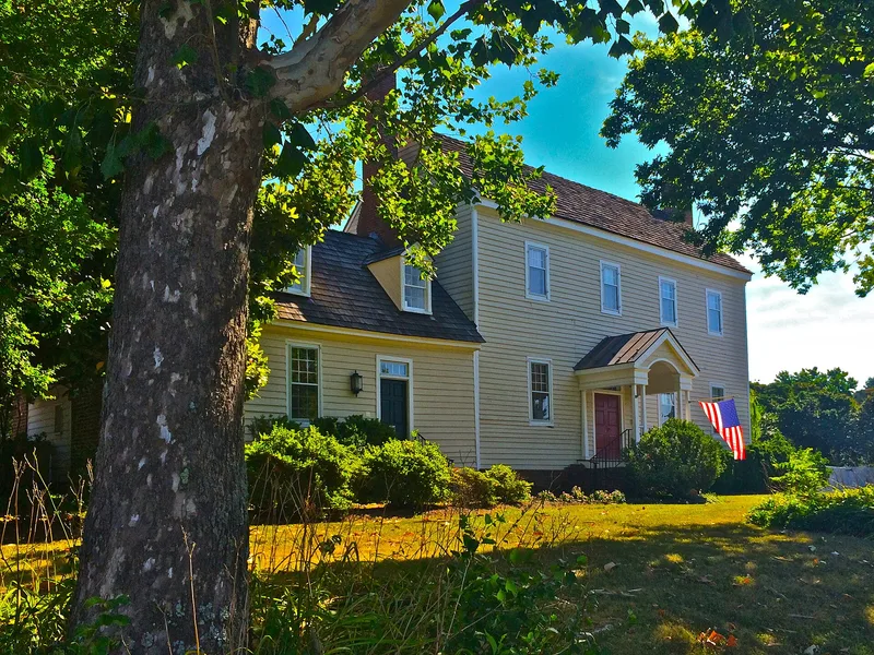

Why it's listed
Trabue's Tavern, known to its nineteenth-century owners as Pleasant View plantation, sits on the old Buckingham Road near Midlothian in Chesterfield County. The frame house has two parts: a one-and-one-half-story western wing reputedly built around 1730, and a later two-story eastern wing that is brick nogged. Behind it, a street of early-nineteenth-century outbuildings survives, including a well house, a dairy with a dovecote, a smokehouse with an attached laundry, two kitchens, a schoolhouse, and a family graveyard enclosed by a cast-iron fence. The Trabue family, descended from a Huguenot refugee, owned the property until 1956 and mined coal nearby, and the house also served as an inn for travelers and miners. It is valued as a reminder of Midlothian's early coal industry and for the unusual survival of so many plantation outbuildings together, though a housing development now surrounds the property.
Significance in brief: It is presented as a relic of Midlothian's coal-producing era and an important example of a Southside plantation complex. The house was home to a principal mine-owning family and served as an inn for travelers and miners. Its street of early-nineteenth-century outbuildings is described as unrivaled in the area.
Machine-generated summary. This summary was generated by a language model from the official nomination document and has not been reviewed line by line by an editor. It may contain errors. Check the source document before relying on any detail. Source: nomination document (PDF) · National Archives catalog entry. NRHP reference 75002018, listed June 10, 1975. Summary generated October 2026 (model claude-sonnet-5-5, prompt v1.0-2026-10-29, confidence high).
Key facts
| Address | 1.5 mi. E of Midlothian on VA 677, Midlothian |
|---|---|
| County | Chesterfield County |
| Listed | June 10, 1975 |
| Reference number | 75002018 |
| Resource type | Building |
| Period of significance | 18th and 19th centuries |
| Architectural style | Vernacular |
| Areas of significance | Agriculture, Architecture |
| Level of significance | State |
| Status (as stated in the nomination) | Private residence in good condition, altered, on its original site; now surrounded by a housing development. |
| Acreage | 4 |
| Coordinates | 37.51172, -77.62137 (NPS GIS) |
What listing means for this property
National Register listing is honorary: it recognises significance and does not restrict what a private owner may do without federal money or permits. It unlocks the 20% federal rehabilitation tax credit for income-producing buildings, state credits in many states, and Section 106 review when federal agencies are involved. See what listing means in practice.
General information, not legal or tax advice. Rules change; confirm with your State Historic Preservation Office or a qualified adviser.
Sources and further reading
- National Park Service, National Register of Historic Places database (snapshot May 2026), reference 75002018.
- Nomination form (PDF, National Archives) — catalog entry
- Wikipedia article (used for cross-checking only; text not reproduced here)
- Wikidata Q14713077
- This listing as JSON
Last updated October 2026. Found an error? See the editorial policy for how to report it.