Falling Creek UDC Jefferson Davis Highway Marker
Also known as: Dhr#127-6150-0003

Why it's listed
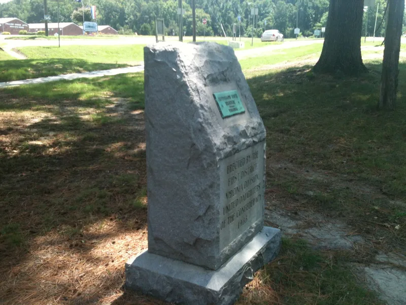
A rough-cut gray granite boulder in the median of U.S. Route 1 at Falling Creek Wayside Park, south of Richmond, marks the Jefferson Davis Highway in Chesterfield County. The stone stands 49 inches tall on an 8-inch granite base and carries a bronze plaque and an inscription crediting the First District, Virginia Division, United Daughters of the Confederacy, 1933. It was ordered from a Richmond firm, made of Burkeville granite, and cost $165. Planned dedication ceremonies were abandoned because of weather. The marker is one of sixteen placed in Virginia between 1927 and 1947 as part of a cross-country memorial highway promoted by the UDC. It was listed for its association with the era of named highways and as an achievement of a women's organization, with a period of significance of 1933-1934. It sits beside an 1820s stone bridge, and the wayside park, dedicated in 1934, was the first of its kind in Virginia.
Significance in brief: It is one of sixteen United Daughters of the Confederacy markers placed along the Jefferson Davis Highway in Virginia between 1927 and 1947. It is significant at the statewide level under Criterion A in Transportation and Social History, tied to the era of privately named highways and to a major undertaking by a women's organization. It also meets the consideration for commemorative properties.
Machine-generated summary. This summary was generated by a language model from the official nomination document and has not been reviewed line by line by an editor. It may contain errors. Check the source document before relying on any detail. Source: nomination document (PDF) · National Archives catalog entry. NRHP reference 12001220, listed January 23, 2013. Summary generated October 2026 (model claude-sonnet-5-5, prompt v1.0-2026-10-29, confidence high).
Key facts
| Address | US 1 at Falling Cr. Wayside, Richmond |
|---|---|
| County | Chesterfield County |
| Listed | January 23, 2013 |
| Reference number | 12001220 |
| Resource type | Object |
| Period of significance | 1933-1934 |
| Criteria |
|
| Areas of significance | Transportation, Social History |
| Level of significance | State |
| Status (as stated in the nomination) | The marker remains in its original location in the highway median and retains integrity; it is currently maintained by a UDC chapter. |
| Acreage | 0.9 |
| Coordinates | 37.43903, -77.43908 (NPS GIS) |
What listing means for this property
National Register listing is honorary: it recognises significance and does not restrict what a private owner may do without federal money or permits. It unlocks the 20% federal rehabilitation tax credit for income-producing buildings, state credits in many states, and Section 106 review when federal agencies are involved. See what listing means in practice.
General information, not legal or tax advice. Rules change; confirm with your State Historic Preservation Office or a qualified adviser.
Sources and further reading
- National Park Service, National Register of Historic Places database (snapshot May 2026), reference 12001220.
- Nomination form (PDF, National Archives) — catalog entry
- Wikipedia article (used for cross-checking only; text not reproduced here)
- Wikidata Q14712306
- This listing as JSON
Last updated October 2026. Found an error? See the editorial policy for how to report it.