Grove, The

Why it's listed
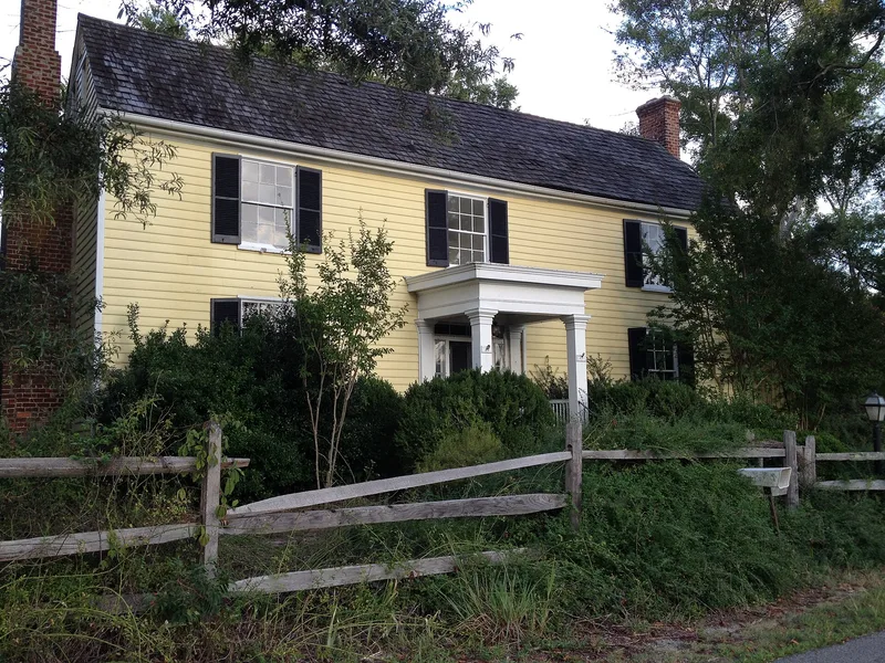
The Grove is a frame farmhouse on 68 acres beside Mt. Gideon Road in southern Caroline County, Virginia, a route also designated the Washington-Rochambeau Revolutionary Route. Its oldest part, a two-and-a-half-story building with one room per floor, was probably built around 1787 by or for Susannah Foster. Around 1800 a northern section was added, creating a center-passage plan, likely under owner Thomas Taylor. About 1858 Dr. Robert T. Wortham added a rear shed wing that housed his family and medical practice, and further additions followed in the later 19th and mid 20th centuries. Original features include hewn oak sills, hand-wrought lath nails, Flemish bond chimneys, and wide-muntin nine-over-nine windows. The property also includes a smokehouse from the early 19th century and a water tower from about 1920. The Grove is valued as a well-preserved example of a Tidewater farmhouse that grew with its occupants over roughly 170 years.
Significance in brief: The house is presented as an excellent example of an 18th-century Tidewater Virginia farmhouse along a former stagecoach route that evolved through five building campaigns into the 20th century. The surviving fabric shows construction techniques from the late 18th century through the mid-19th century. The form also ties it to Susannah Foster, an early woman landowner, and to Dr. Robert T. Wortham, who added a wing for his family and medical practice.
Machine-generated summary. This summary was generated by a language model from the official nomination document and has not been reviewed line by line by an editor. It may contain errors. Check the source document before relying on any detail. Source: nomination document (PDF) · National Archives catalog entry. NRHP reference 09000333, listed May 21, 2009. Summary generated October 2026 (model claude-sonnet-5-5, prompt v1.0-2026-10-29, confidence medium).
Key facts
| Address | 33115 Mount Gideon Rd., Hanover |
|---|---|
| County | Caroline County |
| Listed | May 21, 2009 |
| Reference number | 09000333 |
| Resource type | Building |
| Architectural style | Colonial/Early Republic: Vernacular; Mid 19th Century: Greek Revival; Mid 20th Century: Colonial Revival |
| Areas of significance | Architecture |
| Level of significance | Local |
| Status (as stated in the nomination) | Still used as a single dwelling, with a cemetery and agricultural animal facilities among its current functions. |
| Acreage | 68 |
| Coordinates | 37.80792, -77.36500 (NPS GIS) |
What listing means for this property
National Register listing is honorary: it recognises significance and does not restrict what a private owner may do without federal money or permits. It unlocks the 20% federal rehabilitation tax credit for income-producing buildings, state credits in many states, and Section 106 review when federal agencies are involved. See what listing means in practice.
General information, not legal or tax advice. Rules change; confirm with your State Historic Preservation Office or a qualified adviser.
Sources and further reading
- National Park Service, National Register of Historic Places database (snapshot May 2026), reference 09000333.
- Nomination form (PDF, National Archives) — catalog entry
- Wikipedia article (used for cross-checking only; text not reproduced here)
- Wikidata Q14713303
- This listing as JSON
Last updated October 2026. Found an error? See the editorial policy for how to report it.