Galt's Mill Complex
Also known as: DHR file no. 005-5037

Why it's listed
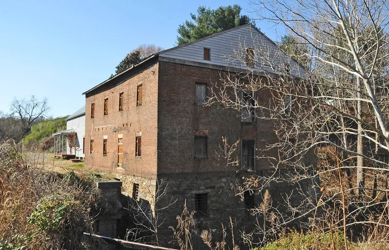
Galt's Mill Complex is a rural mill village on the James River in southeast Amherst County, Virginia, where Stovall Creek, now Beck Creek, meets the river. Its centerpiece is a brick mill dated 1813, surrounded by a c. 1900 store, a c. 1830s stone aqueduct, a boathouse, several vernacular houses and a range of log, frame and concrete barns. The mill was once five and one-half stories but was cut to two stories around 1950 because of structural problems. Inside, hand-planed supports and much of the milling machinery remain, based on an automated system patented by Oliver Evans. The mill operated until 1956. The aqueduct first carried the James River and Kanawha Canal and later a railroad line that still runs through the property. Owners included William Galt, the Warwick family, David Staples and the Turner family. The 535-acre property keeps the look of a working milling community and is protected by a conservation easement.
Significance in brief: The complex preserves a largely intact mill village that operated from 1813 to 1956, with the mill retaining much of its early automated milling equipment. It shows how milling, farming, river and canal transport, and later rail shaped the area. The surrounding landscape retains its setting and integrity, and the property remained in related family ownership for generations.
Machine-generated summary. This summary was generated by a language model from the official nomination document and has not been reviewed line by line by an editor. It may contain errors. Check the source document before relying on any detail. Source: nomination document (PDF) · National Archives catalog entry. NRHP reference 09000791, listed September 30, 2009. Summary generated October 2026 (model claude-sonnet-5-5, prompt v1.0-2026-10-29, confidence medium).
Key facts
| Address | 1133 Galt's Mill Rd., Madison Heights |
|---|---|
| County | Amherst County |
| Listed | September 30, 2009 |
| Reference number | 09000791 |
| Resource type | District |
| Architectural style | Vernacular |
| Areas of significance | Architecture, Industry, Commerce, Transportation |
| Level of significance | Local |
| Status (as stated in the nomination) | The mill closed in 1956 but its equipment largely remains. Many houses and farm buildings are in use, while the boathouse is deteriorated and unused. The property is under easement with the Virginia Outdoors Foundation. |
| Acreage | 535 |
| Coordinates | 37.45364, -79.01412 (NPS GIS) |
What listing means for this property
This is a historic district. Buildings within its boundary are either contributing (they add to the district's significance) or non-contributing. Owners of contributing income-producing buildings can claim the 20% federal rehabilitation tax credit; homeowners should look at state credits. National Register districts impose no design review by themselves; a local historic district ordinance, if one exists, does (the difference explained).
General information, not legal or tax advice. Rules change; confirm with your State Historic Preservation Office or a qualified adviser.
Sources and further reading
- National Park Service, National Register of Historic Places database (snapshot May 2026), reference 09000791.
- Nomination form (PDF, National Archives) — catalog entry
- Wikipedia article (used for cross-checking only; text not reproduced here)
- Wikidata Q14712349
- This listing as JSON
Last updated October 2026. Found an error? See the editorial policy for how to report it.