Saffold Dam
Also known as: Starcke Park Dam

Why it's listed
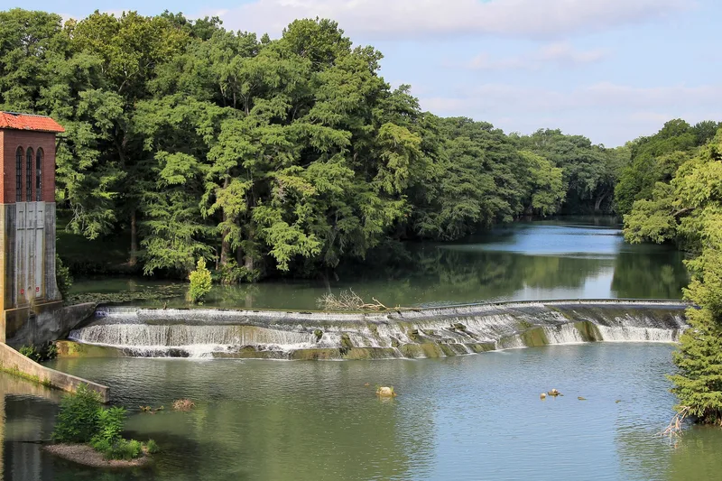
Saffold Dam crosses the Guadalupe River in Max Starcke Park in Seguin, Texas. It began around 1853 as little more than a line of boulders on a natural rock outcropping and was raised and reinforced over the decades. Today it consists of three reverse curves about 250 feet long, built of boulders, smaller stones and gravel, and covered in concrete. A low concrete crest wall was added in the summer of 1934, raising the water level 12 to 18 inches. The dam served mills, a ferry, a cotton gin and a hydro-electric plant on the river's south bank, and the city of Seguin acquired the falls and water rights in 1907. It has been repaired and improved by the city since. It still supports a water treatment plant and a power plant and forms a recreational pool. It is considered a rare surviving example of the stone mill dams once common on central Texas rivers.
Significance in brief: The dam is tied to the settlement of Seguin and supplied power and water for local mills, a cotton gin, and electric and water plants. It is also one of few surviving examples of the mill dams built on central Texas rivers in the 19th and early 20th centuries. It began as a natural rock outcropping built up with boulders and was gradually strengthened.
Machine-generated summary. This summary was generated by a language model from the official nomination document and has not been reviewed line by line by an editor. It may contain errors. Check the source document before relying on any detail. Source: nomination document (PDF) · National Archives catalog entry. NRHP reference 79002950, listed November 15, 1979. Summary generated October 2026 (model claude-sonnet-5-5, prompt v1.0-2026-10-29, confidence high).
Key facts
| Address | Off TX 123, Seguin |
|---|---|
| County | Guadalupe County |
| Listed | November 15, 1979 |
| Reference number | 79002950 |
| Resource type | Site |
| Period of significance | c. 1853 (specific date given; 1800-1899 period checked) |
| Areas of significance | Industry, Engineering, Exploration/Settlement |
| Level of significance | Local |
| Status (as stated in the nomination) | Described as structurally sound and in good condition; it still impounds the river and is used by an adjacent city water plant and a power plant. The park is publicly owned and accessible. |
| Acreage | 0.9 |
| Coordinates | 29.55120, -97.97033 (NPS GIS) |
What listing means for this property
Sites (archaeological sites, battlefields, landscapes) are often listed with a restricted address to protect them from looting or disturbance. Listing is honorary for private owners; federal undertakings on or near the site go through Section 106 review, and state laws may protect burials and artefacts regardless of listing.
General information, not legal or tax advice. Rules change; confirm with your State Historic Preservation Office or a qualified adviser.
Sources and further reading
- National Park Service, National Register of Historic Places database (snapshot May 2026), reference 79002950.
- Nomination form (PDF, National Archives) — catalog entry
- Wikipedia article (used for cross-checking only; text not reproduced here)
- Wikidata Q7398706
- This listing as JSON
Last updated October 2026. Found an error? See the editorial policy for how to report it.