Wilson Homesite

Why it's listed
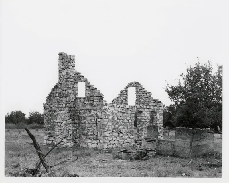
Ruined walls of a limestone farmhouse mark the Wilson homesite, set on level ground at the southern end of Bee Rock Flats, roughly 3.25 miles west of Clifton in Bosque County. The location is remote and almost inaccessible by car. Local residents say the house burned around 1950, leaving it without a roof. It was rectangular with a gabled roof and faced west. Its plaster has worn away, exposing limestone and the original mud and clay mortar. Large stone lintels span the openings, though all doors and window sashes are gone. An exterior stone chimney rises at the north end, and an external stairway probably led to a loft. Nearby are a concrete wall, a stone-lined underground cistern, a dug-out cellar, foundations of two outbuildings and what may be settlers' graves. The house was apparently the home of Fred or John Wilson. Its mortar suggests an early date, possibly the 1860s, and the scatter of crockery and other refuse points to archeological potential.
Significance in brief: The nomination argues the site has archeological potential. Mud and clay mortar construction suggests an early date, possibly the 1860s. A surface scatter of crockery shards, wood fragments and other historic refuse was found, along with remains of a cellar, outbuilding foundations and possible graves.
Machine-generated summary. This summary was generated by a language model from the official nomination document and has not been reviewed line by line by an editor. It may contain errors. Check the source document before relying on any detail. Source: nomination document (PDF) · National Archives catalog entry. NRHP reference 83003127, listed July 22, 1983. Summary generated October 2026 (model claude-sonnet-5-5, prompt v1.0-2026-10-29, confidence medium).
Key facts
| Address | W of Clifton, Clifton |
|---|---|
| County | Bosque County |
| Listed | July 22, 1983 |
| Reference number | 83003127 |
| Resource type | Structure |
| Areas of significance | European, Exploration/Settlement, Architecture |
| Level of significance | National |
| Status (as stated in the nomination) | Ruins; unoccupied and abandoned since the house burned about 1950. Current use is listed as ruins and agriculture. |
| Acreage | 0.9 |
| Coordinates | 31.77851, -97.62916 (NPS GIS) |
What listing means for this property
National Register listing is honorary: it recognises significance and does not restrict what a private owner may do without federal money or permits. It unlocks the 20% federal rehabilitation tax credit for income-producing buildings, state credits in many states, and Section 106 review when federal agencies are involved. See what listing means in practice.
Noted as vacant in the nomination. Nomination documents can be decades old; current status may differ. If you are considering buying an empty listed property, read the due-diligence checklist.
General information, not legal or tax advice. Rules change; confirm with your State Historic Preservation Office or a qualified adviser.
Sources and further reading
- National Park Service, National Register of Historic Places database (snapshot May 2026), reference 83003127.
- Nomination form (PDF, National Archives) — catalog entry
- Wikidata Q110000365
- This listing as JSON
Last updated October 2026. Found an error? See the editorial policy for how to report it.