Bixler, Michael and Magdealena Farmstead
Also known as: John Rudy County Park

Why it's listed
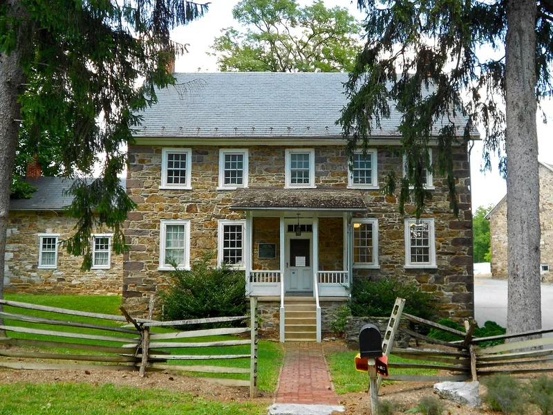
Located on the north side of Codorus Creek in northeastern York County, Pennsylvania, the Bixler Farmstead grew from a 100-acre tract Christian Bixler bought in 1737. The farmhouse, built about 1799 with rough-cut quartzite walls, brownstone quoins and a slate gable roof, is the oldest building on the site. Michael and Magdalena Bixler, third-generation owners, built the three oldest and most prominent buildings. The farm stayed in the Bixler and Rudy families until 1973, when it was donated to York County and named for John Rudy. The nomination regards the group as a representative York County farmstead. Its buildings combine Pennsylvania German and English stylistic traits and still reflect farming from the early 1700s through the early 1900s, despite the loss of surrounding fields. Today the farmhouse serves county park administration.
Significance in brief: The nomination argues the farmstead is a strong representative example of a typical York County farm operating from the early 18th century through the first half of the 20th century, with resources that still reflect their agricultural origins. It also argues the buildings show both Pennsylvania German and English stylistic influences.
Machine-generated summary. This summary was generated by a language model from the official nomination document and has not been reviewed line by line by an editor. It may contain errors. Check the source document before relying on any detail. Source: nomination document (PDF) · National Archives catalog entry. NRHP reference 00000850, listed July 27, 2000. Summary generated October 2026 (model claude-haiku-5-5, prompt v1.1-2026-10-29, confidence medium).
Key facts
| Address | 400 Mundis Race Rd., East Manchester |
|---|---|
| County | York County |
| Listed | July 27, 2000 |
| Reference number | 00000850 |
| Resource type | Building |
| Period of significance | C. 1737-1950 |
| Architectural style | Georgian |
| Criteria |
|
| Areas of significance | Agriculture, Architecture |
| Level of significance | Local |
| Status (as stated in the nomination) | Currently used as park administration offices and storage facilities, within John Rudy County Park. |
| Acreage | 3.5 |
| Coordinates | 40.02092, -76.70408 (NPS GIS) |
What listing means for this property
National Register listing is honorary for a privately owned home: it does not by itself restrict what an owner may do with their own money, and it does not require public access. Restrictions come from local landmark or historic-district ordinances, which are separate (how they differ).
Owner-occupied houses are not eligible for the 20% federal rehabilitation tax credit, which applies to income-producing buildings, but many states offer credits for homeowners. Listing also opens the door to preservation easements and to buying a plaque. Start with what listing means for homeowners, renovating a listed house and selling one.
General information, not legal or tax advice. Rules change; confirm with your State Historic Preservation Office or a qualified adviser.
Sources and further reading
- National Park Service, National Register of Historic Places database (snapshot May 2026), reference 00000850.
- Nomination form (PDF, National Archives) — catalog entry
- Wikipedia article (used for cross-checking only; text not reproduced here)
- Wikidata Q15253312
- This listing as JSON
Last updated October 2026. Found an error? See the editorial policy for how to report it.