Pennsylvania Main Line Canal, Juniata Division, Canal Section

Why it's listed
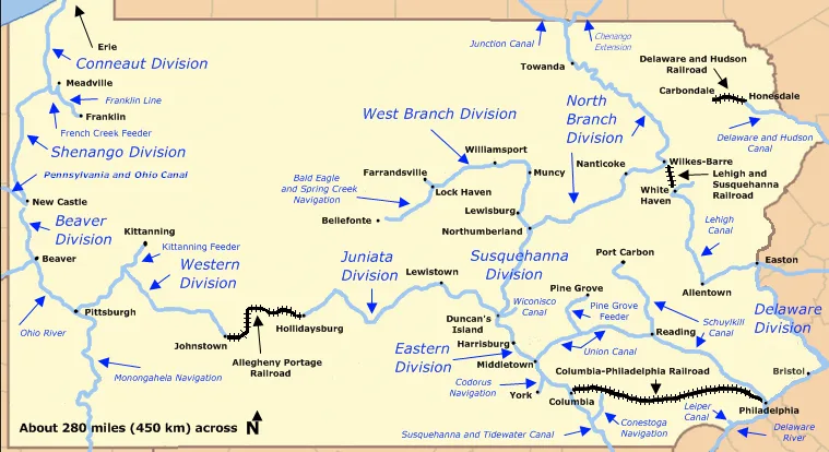
Located southwest of Lewistown in Mifflin County, this 8,420-foot stretch of the Juniata Division canal was completed in 1830 as part of the Pennsylvania Main Line Canal, which linked Philadelphia and Pittsburgh. The canal carried heavy freight such as iron and coal to urban markets at far lower cost than road haulage, and the Juniata valley's iron industry depended on it. The Pennsylvania Railroad bought the canal in 1857, and this section operated until the flood of 1889. Its two sets of original stone bridge abutments and the canal prism, towpath and clay liner survive from the original construction. Restoration by a private partnership began in 1970 and was completed in 1986, and the reach is the longest restored and rewatered part of the entire system. Its significance lies in transportation history and in its engineering, notably the surviving abutments and the canal's form.
Significance in brief: The nomination argues that this section was part of the uninterrupted transportation route between Philadelphia and Pittsburgh and that it is the only restored and rewatered part of the 127.5-mile Juniata Division. It also cites the canal's role in carrying bulky freight, including iron and coal, and its contribution to the regional iron industry. Its engineering and the surviving original abutments and canal form are presented as the basis for its significance.
Machine-generated summary. This summary was generated by a language model from the official nomination document and has not been reviewed line by line by an editor. It may contain errors. Check the source document before relying on any detail. Source: nomination document (PDF) · National Archives catalog entry. NRHP reference 02000069, listed February 20, 2002. Summary generated October 2026 (model claude-haiku-5-5, prompt v1.1-2026-10-29, confidence medium).
Key facts
| Address | 1.5 mi. section of canal bet. PA RR Main Line and Juniata River, Granville Township |
|---|---|
| County | Mifflin County |
| Listed | February 20, 2002 |
| Reference number | 02000069 |
| Resource type | Structure |
| Period of significance | 1830-1889 |
| Architect / builder | Clinton, DeWitt Jr., Engineer |
| Criteria |
|
| Areas of significance | Transportation, Engineering |
| Level of significance | State |
| Status (as stated in the nomination) | Restored between 1970 and 1986 and rewatered; the canal is dry or watered according to its restored state, with campgrounds and a subdivision along part of its length. |
| Acreage | 13.6 |
| Coordinates | 40.56356, -77.59169 (NPS GIS) |
What listing means for this property
National Register listing is honorary: it recognises significance and does not restrict what a private owner may do without federal money or permits. It unlocks the 20% federal rehabilitation tax credit for income-producing buildings, state credits in many states, and Section 106 review when federal agencies are involved. See what listing means in practice.
General information, not legal or tax advice. Rules change; confirm with your State Historic Preservation Office or a qualified adviser.
Sources and further reading
- National Park Service, National Register of Historic Places database (snapshot May 2026), reference 02000069.
- Nomination form (PDF, National Archives) — catalog entry
- Wikipedia article (used for cross-checking only; text not reproduced here)
- Wikidata Q6736015
- This listing as JSON
Last updated October 2026. Found an error? See the editorial policy for how to report it.