Witmer's Tavern

Why it's listed
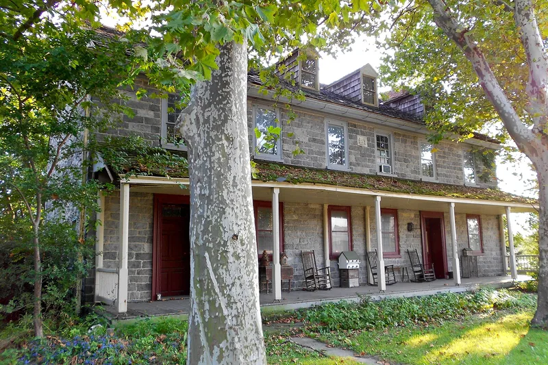
Built in two sections of blue limestone, the Witmer Tavern on the Old Philadelphia Pike near Lancaster began as a circa 1725 building at its east end. In 1773 Henry Witmer added the larger west section, marked by a datestone bearing the initials HW and MW and the year. The house has sixteen rooms on two floors and an attic, a central hall running its full depth, and original brick kitchen flooring. It stood at the 64th mile of the Philadelphia to Lancaster Turnpike, where the road crossed the Conestoga River. Taverns along this route provided meals, lodging and local news to travelers. Abraham Witmer, who acquired the property in 1806, was a tax assessor for Lampeter Township and was authorized to run a toll bridge over the Conestoga Creek. The tavern is regarded as one of the best surviving examples of its type in the county.
Significance in brief: The nomination argues the tavern is one of the best examples of an 18th-century tavern in Lancaster County. It is tied to the Philadelphia to Lancaster Turnpike, where lodging and travel services were offered, and to Abraham Witmer, who was authorized to operate a toll bridge over the Conestoga Creek and was a prominent local innkeeper.
Machine-generated summary. This summary was generated by a language model from the official nomination document and has not been reviewed line by line by an editor. It may contain errors. Check the source document before relying on any detail. Source: nomination document (PDF) · National Archives catalog entry. NRHP reference 78002416, listed December 1, 1978. Summary generated October 2026 (model claude-haiku-5-5, prompt v1.1-2026-10-29, confidence medium).
Key facts
| Address | 2014 Old Philadelphia Pike, Lancaster |
|---|---|
| County | Lancaster County |
| Listed | December 1, 1978 |
| Reference number | 78002416 |
| Resource type | Building |
| Period of significance | 1700-1799 |
| Areas of significance | Commerce |
| Level of significance | Local |
| Status (as stated in the nomination) | The tavern is currently being restored. |
| Acreage | 1 |
| Coordinates | 40.03987, -76.24169 (NPS GIS) |
What listing means for this property
For an income-producing building, listing (individually or as a contributing building in a district) is the gateway to the 20% federal rehabilitation tax credit on qualified rehabilitation costs, often stackable with state credits. Work claiming the credit must follow the Secretary of the Interior's Standards and be approved in advance.
Listing does not restrict a private owner acting without federal money or permits; where federal funding or licensing is involved, Section 106 review applies.
General information, not legal or tax advice. Rules change; confirm with your State Historic Preservation Office or a qualified adviser.
Sources and further reading
- National Park Service, National Register of Historic Places database (snapshot May 2026), reference 78002416.
- Nomination form (PDF, National Archives) — catalog entry
- Wikipedia article (used for cross-checking only; text not reproduced here)
- Wikidata Q8028363
- This listing as JSON
Last updated October 2026. Found an error? See the editorial policy for how to report it.