Columbia Historic District

The pin is a point inside the NPS boundary polygon, not a surveyed location.
Why it's listed
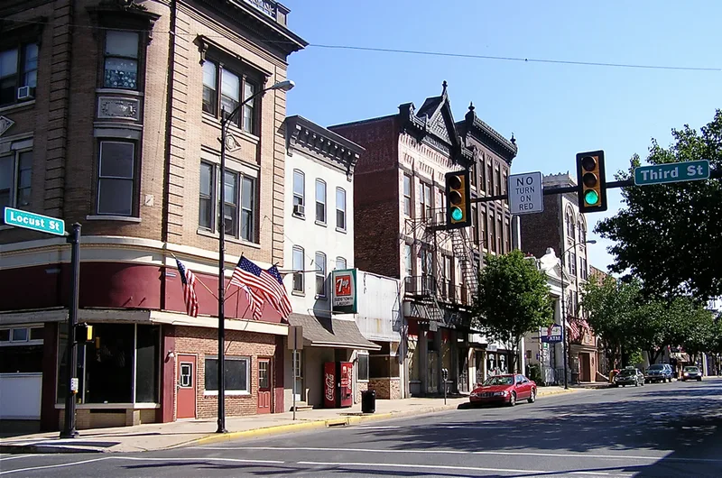
Columbia's historic district lies on the eastern bank of the Susquehanna River and includes about 950 buildings covering roughly a third of the borough. Its growth followed the ferry established at Wrights' Ferry in 1730, which became a gateway to the west, and later the canal of 1797 and the first bridge of 1814. Riverfront wharves, sawmills and warehouses turned the town into a major lumber and transshipment center. The houses are mostly brick, produced locally from the early nineteenth century, and follow a common two-thirds Georgian plan in Federal, Greek Revival and Italianate versions. Locust Street forms the commercial core, with storefronts ranging from Victorian to modern. Chestnut Street held elaborate residences of professionals and managers from 1871 onward. The district's preserved streetscapes reflect the town's economic strength across two centuries.
Significance in brief: The nomination argues the district illustrates two centuries of Columbia's growth as a transportation and industrial center, beginning with Wrights' Ferry in 1730 and continuing through river, canal, rail and road trade. It also cites the district's well preserved architecture from the 18th through 20th centuries as reflecting the town's prosperity and prominence.
Machine-generated summary. This summary was generated by a language model from the official nomination document and has not been reviewed line by line by an editor. It may contain errors. Check the source document before relying on any detail. Source: nomination document (PDF) · National Archives catalog entry. NRHP reference 83002249, listed May 6, 1983. Summary generated October 2026 (model claude-haiku-5-5, prompt v1.1-2026-10-29, confidence medium).
Key facts
| Address | Roughly bounded by Susquehanna River, Union, Cedar, 4th, and 5th Sts., Chestnut to 9th St., Columbia |
|---|---|
| County | Lancaster County |
| Listed | May 6, 1983 |
| Reference number | 83002249 |
| Resource type | District |
| Period of significance | 1730-1930 |
| Architectural style | Eighteenth Century Traditional, Federal, Greek Revival, Italianate, Queen Anne, Second Empire, Romanesque Revival, Beaux Arts, Colonial Revival, Art Deco |
| Areas of significance | Commerce, Transportation, Exploration/Settlement, Architecture |
| Level of significance | Local |
| Status (as stated in the nomination) | Most structures remain intact or altered only superficially, according to the description. |
| Acreage | 171 |
| Coordinates | 40.03378, -76.49892 (NPS GIS) |
What listing means for this property
This is a historic district. Buildings within its boundary are either contributing (they add to the district's significance) or non-contributing. Owners of contributing income-producing buildings can claim the 20% federal rehabilitation tax credit; homeowners should look at state credits. National Register districts impose no design review by themselves; a local historic district ordinance, if one exists, does (the difference explained).
General information, not legal or tax advice. Rules change; confirm with your State Historic Preservation Office or a qualified adviser.
Sources and further reading
- National Park Service, National Register of Historic Places database (snapshot May 2026), reference 83002249.
- Nomination form (PDF, National Archives) — catalog entry
- Wikipedia article (used for cross-checking only; text not reproduced here)
- Wikidata Q5149729
- This listing as JSON
Last updated October 2026. Found an error? See the editorial policy for how to report it.