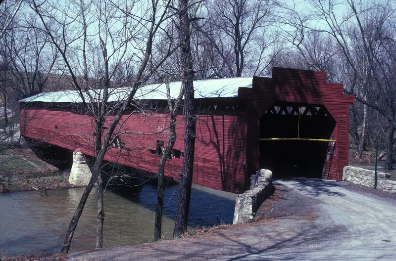
Martin's Mill Covered Bridge

Why it's listed
Spanning a stream in Franklin County, Pennsylvania, this lattice-type covered bridge occupies the site of an early grist and saw mill, with settlement in the area dating to the 1730s or early 1740s. Citizens petitioned the county court in January 1849 for a bridge at the mill crossing, and the board of viewers agreed it was needed and cheaper to build on that site than at the original ford. The bridge served as an approach to the mills and an east-west link between Antrim and Montgomery Townships. Repairs followed flood damage in 1936 and a truck collapse in 1948. In 1958 the county voted to demolish it, but after a court fight and a 1962 transfer to a non-profit association, it was rebuilt following Hurricane Agnes. It is regarded as the longest lattice-type covered bridge in Pennsylvania and a surviving example of a bridge type that was largely lost in the 1972 floods.
Significance in brief: The nomination argues the bridge is significant as the longest lattice covered bridge in the Commonwealth and as an example of a vanishing bridge type, despite alterations from destruction and restoration. It also cites its role as a long-used east-west link between Antrim and Montgomery Townships, and the local preservation effort that saved it from demolition.
Machine-generated summary. This summary was generated by a language model from the official nomination document and has not been reviewed line by line by an editor. It may contain errors. Check the source document before relying on any detail. Source: nomination document (PDF) · National Archives catalog entry. NRHP reference 74001786, listed February 15, 1974. Summary generated October 2026 (model claude-haiku-5-5, prompt v1.1-2026-10-29, confidence medium).
Key facts
| Address | SW of Greencastle over Conococheague Creek, Greencastle |
|---|---|
| County | Franklin County |
| Listed | February 15, 1974 |
| Reference number | 74001786 |
| Resource type | Structure |
| Period of significance | 1849 |
| Areas of significance | Transportation |
| Level of significance | State |
| Status (as stated in the nomination) | Reconstructed after damage from Hurricane Agnes and reopened to passenger traffic under a three ton weight limit. |
| Acreage | 0.9 |
| Coordinates | 39.76499, -77.77569 (NPS GIS) |
What listing means for this property
For a publicly owned building or structure, listing mainly matters when federal funds, permits or licences are involved: projects then go through Section 106 review so effects on the property are considered. Listing also strengthens applications for preservation grants and, for leased income-producing uses, can enable the federal rehabilitation tax credit.
General information, not legal or tax advice. Rules change; confirm with your State Historic Preservation Office or a qualified adviser.
Sources and further reading
- National Park Service, National Register of Historic Places database (snapshot May 2026), reference 74001786.
- Nomination form (PDF, National Archives) — catalog entry
- Wikipedia article (used for cross-checking only; text not reproduced here)
- Wikidata Q15249032
- This listing as JSON
Last updated October 2026. Found an error? See the editorial policy for how to report it.