Lafayette's Quarters

Why it's listed
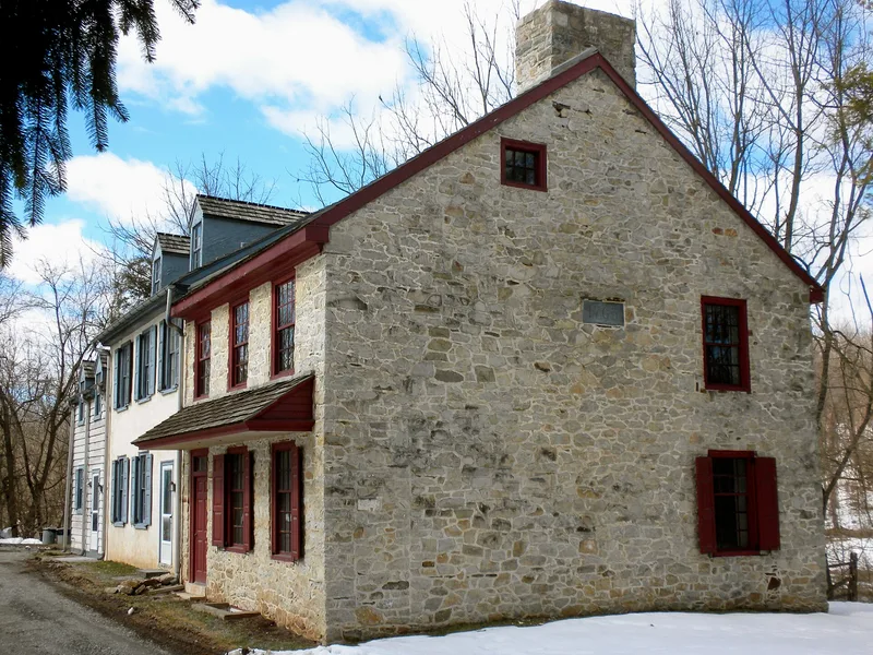
Built in 1763 by Samuel Havard, a farmer in the Valley Creek area, this two-and-a-half-storey stone farmhouse was later extended with a central section of about 1837-1839 and a frame west section dated 1882-1900. The original east section has a gabled roof, a single end chimney and a date stone reading 1763 set between the second-floor windows. During the Continental Army's encampment at Valley Forge in the winter of 1777-1778, Major General Marquis de Lafayette was assigned quarters in the house, and he later described them as a small barrack scarcely more cheerful than dungeons. Havard and his sisters slept upstairs while Lafayette and his staff occupied the two ground-floor rooms. The house is significant for this direct association with Lafayette's wartime stay, and for its surviving eighteenth-century fabric within the later additions.
Significance in brief: The house served as quarters for Major General Marquis de Lafayette during the Continental Army's encampment at Valley Forge in 1777-1778. The nomination links the property to that military occupation, and the surrounding area held quarters for other officers including General Knox, General Maxwell and General Lord Stirling.
Machine-generated summary. This summary was generated by a language model from the official nomination document and has not been reviewed line by line by an editor. It may contain errors. Check the source document before relying on any detail. Source: nomination document (PDF) · National Archives catalog entry. NRHP reference 74001774, listed June 20, 1974. Summary generated October 2026 (model claude-haiku-5-5, prompt v1.1-2026-10-29, confidence high).
Key facts
| Address | SE of Valley Forge on Wilson Rd., Valley Forge |
|---|---|
| County | Chester County |
| Listed | June 20, 1974 |
| Reference number | 74001774 |
| Resource type | Building |
| Period of significance | 1777-1778 |
| Architect / builder | Samuel Havard (builder of the 1763 east section) |
| Areas of significance | Military |
| Level of significance | National |
| Status (as stated in the nomination) | Renovated in 1948; the form describes the property as altered, in good condition, and at its original site. |
| Acreage | 35 |
| Coordinates | 40.07244, -75.45778 (NPS GIS) |
What listing means for this property
National Register listing is honorary: it recognises significance and does not restrict what a private owner may do without federal money or permits. It unlocks the 20% federal rehabilitation tax credit for income-producing buildings, state credits in many states, and Section 106 review when federal agencies are involved. See what listing means in practice.
General information, not legal or tax advice. Rules change; confirm with your State Historic Preservation Office or a qualified adviser.
Sources and further reading
- National Park Service, National Register of Historic Places database (snapshot May 2026), reference 74001774.
- Nomination form (PDF, National Archives) — catalog entry
- Wikipedia article (used for cross-checking only; text not reproduced here)
- Wikidata Q15241241
- This listing as JSON
Last updated October 2026. Found an error? See the editorial policy for how to report it.