Honey Hollow Watershed

Why it's listed
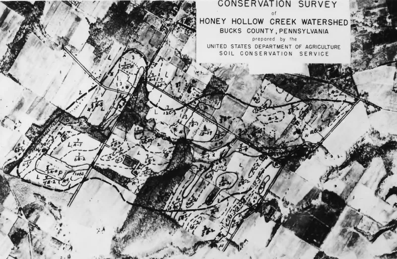
Honey Hollow Watershed is a district of five farms along Honey Hollow Brook near New Hope in Bucks County, Pennsylvania. Its farmhouses and barns include stone dwellings from the early 18th century, one of them dated 1747 and cut into a stone wall, with corner fireplaces, poplar vertical sheathing, and over-door ventilators typical of early southeastern Pennsylvania English-type homes. The Forrest Crooks house and a stone barn are among the buildings photographed in restored condition. The farms are held by the Honey Hollow Watershed Association, whose members worked together on soil and water conservation. The land's management, documented through the Soil Conservation Service and local histories, is regarded as a significant example of watershed conservation. The property was recognized for its combination of colonial buildings and conservation history, which together form a single historic landscape in the Delaware River valley.
Significance in brief: The nomination argues that the combination of 18th-century colonial stone houses and barns with the historically significant conservation work on the watershed, documented from the 1940s through the 1960s, makes the place unique. The houses alone are described as not especially distinctive, but together with the watershed they carry historical and conservation importance.
Machine-generated summary. This summary was generated by a language model from the official nomination document and has not been reviewed line by line by an editor. It may contain errors. Check the source document before relying on any detail. Source: nomination document (PDF) · National Archives catalog entry. NRHP reference 69000155, listed August 4, 1969. Summary generated October 2026 (model claude-haiku-5-5, prompt v1.1-2026-10-29, confidence medium).
Key facts
| Address | 2.5 mi. S of the Delaware River on PA 263, New Hope |
|---|---|
| County | Bucks County |
| Listed | August 4, 1969 |
| Reference number | 69000155 |
| Resource type | District |
| Areas of significance | Conservation, Agriculture |
| Level of significance | National |
| National Historic Landmark | Yes, designated August 4, 1969 |
| Status (as stated in the nomination) | Restored and usable as of 1969 according to the photograph captions; the watershed is in use for agriculture and conservation. |
| Acreage | 650 |
| Coordinates | 40.36883, -75.01435 (NPS GIS) |
What listing means for this property
This is a historic district. Buildings within its boundary are either contributing (they add to the district's significance) or non-contributing. Owners of contributing income-producing buildings can claim the 20% federal rehabilitation tax credit; homeowners should look at state credits. National Register districts impose no design review by themselves; a local historic district ordinance, if one exists, does (the difference explained).
General information, not legal or tax advice. Rules change; confirm with your State Historic Preservation Office or a qualified adviser.
Sources and further reading
- National Park Service, National Register of Historic Places database (snapshot May 2026), reference 69000155.
- Nomination form (PDF, National Archives) — catalog entry
- Wikipedia article (used for cross-checking only; text not reproduced here)
- Wikidata Q5893549
- This listing as JSON
Last updated October 2026. Found an error? See the editorial policy for how to report it.