Bedford Historic District

Why it's listed
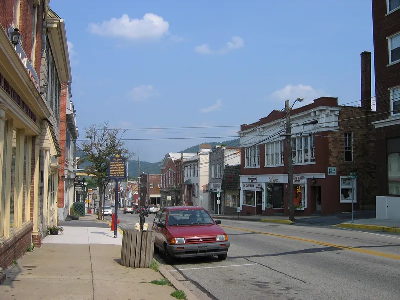
Bedford Borough sits in the Allegheny Mountains on the Raystown Branch of the Juniata River, where a settlement founded in 1750 grew up around Fort Bedford and the east-west road later known as Forbes Road. The district's buildings span from the eighteenth century to 1930 and include Colonial, Federal, Greek Revival, Italianate, Second Empire, Victorian, Beaux Arts and Art Deco examples. Its commercial core lies along Pitt Street, and its central park, the Squares, is surrounded by the county courthouse, churches and the Post Office. The district is significant for its role in frontier military events, including the French and Indian War and the Whiskey Rebellion, when President Washington headquartered in the Espy House. It also reflects the town's growth as a stop on the Pennsylvania Road and the Lincoln Highway, and as a center of inns, hotels and resorts. Architecturally, it is valued for its range of styles and for work by local architects, notably Solomon Filler.
Significance in brief: The nomination argues the district is significant for its role in frontier military activity, including Fort Bedford and the Whiskey Rebellion, for transportation-related commercial growth along the Forbes Road, Pennsylvania Road and Lincoln Highway, and for the quality of craftsmanship and variety of architectural styles, which include work by local architects Solomon Filler and Gibboney.
Machine-generated summary. This summary was generated by a language model from the official nomination document and has not been reviewed line by line by an editor. It may contain errors. Check the source document before relying on any detail. Source: nomination document (PDF) · National Archives catalog entry. NRHP reference 83004187, listed December 22, 1983. Summary generated October 2026 (model claude-haiku-5-5, prompt v1.1-2026-10-29, confidence medium).
Key facts
| Address | Roughly bounded by East, West, and Watson Sts., and the Raystown Branch of Juniata River, Bedford |
|---|---|
| County | Bedford County |
| Listed | December 22, 1983 |
| Reference number | 83004187 |
| Resource type | District |
| Period of significance | 1750-1930 |
| Architectural style | Colonial, Federal, Greek Revival, Georgian, Italianate, Second Empire, Second Renaissance Revival, Victorian, Beaux Arts, Art-Deco, Bungaloid and commercial styles |
| Criteria |
|
| Areas of significance | Commerce, Military, Transportation, Architecture |
| Level of significance | State |
| Acreage | 177 |
| Coordinates | 40.01855, -78.49667 (NPS GIS) |
What listing means for this property
This is a historic district. Buildings within its boundary are either contributing (they add to the district's significance) or non-contributing. Owners of contributing income-producing buildings can claim the 20% federal rehabilitation tax credit; homeowners should look at state credits. National Register districts impose no design review by themselves; a local historic district ordinance, if one exists, does (the difference explained).
General information, not legal or tax advice. Rules change; confirm with your State Historic Preservation Office or a qualified adviser.
Sources and further reading
- National Park Service, National Register of Historic Places database (snapshot May 2026), reference 83004187.
- Nomination form (PDF, National Archives) — catalog entry
- Wikipedia article (used for cross-checking only; text not reproduced here)
- Wikidata Q4879162
- This listing as JSON
Last updated October 2026. Found an error? See the editorial policy for how to report it.