East Carson Street Historic District
Also known as: South Side Flats

Why it's listed
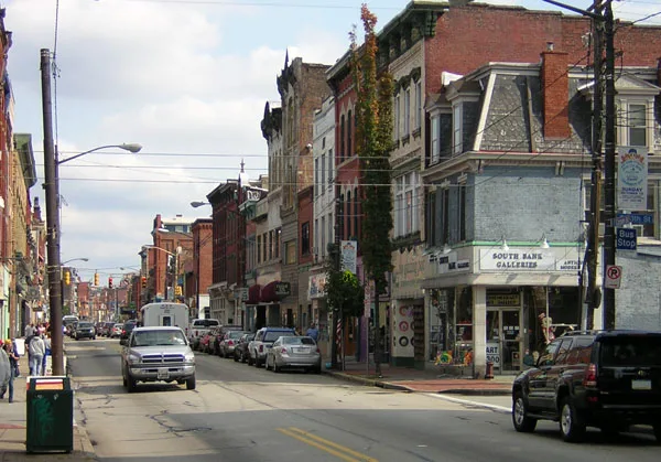
Brick commercial rows, mostly built between 1870 and 1910, line East Carson Street along a mile of the South Side Flats in Pittsburgh. Most are two to four stories high and open directly onto the sidewalk, with contiguous facades forming continuous street walls. Many display Romanesque, Italianate and Second Empire ornament, including brackets, corbelling, cast iron details, leaded glass transoms and cornices. Earlier buildings from the 1850s and 1860s survive around Bedford Square and the old Birmingham settlement. The street was incorporated into the Washington Pike in 1818 and became the area's commercial spine. Local builders including the Benz Brothers and John Seibert produced much of the district's fabric. The district is regarded as the best example of a late nineteenth century low rise commercial district in Allegheny County, and its upper floors preserve much of the original character.
Significance in brief: The district is described as the commercial core of one of Pittsburgh's major industrial and transportation centers in the late 19th and early 20th centuries. Its brick commercial rows in Romanesque, Italianate and Second Empire styles are regarded as Allegheny County's best collection of Victorian commercial row buildings. The street's history as part of the Washington Pike and the area's role in the glass and steel industries add to its importance.
Machine-generated summary. This summary was generated by a language model from the official nomination document and has not been reviewed line by line by an editor. It may contain errors. Check the source document before relying on any detail. Source: nomination document (PDF) · National Archives catalog entry. NRHP reference 83004183, listed November 17, 1983. Summary generated October 2026 (model claude-haiku-5-5, prompt v1.1-2026-10-29, confidence medium).
Key facts
| Address | Roughly E. Carson St. from 9th to 24th St., Pittsburgh |
|---|---|
| County | Allegheny County |
| Listed | November 17, 1983 |
| Reference number | 83004183 |
| Resource type | District |
| Period of significance | 1850-present |
| Architect / builder | Various |
| Architectural style | Romanesque, Italianate and Second Empire |
| Areas of significance | Community Planning and Development, Architecture |
| Level of significance | Local |
| Status (as stated in the nomination) | Restoration activity was underway at the time of nomination, and upper floors are described as largely retaining their integrity. |
| Acreage | 32 |
| Coordinates | 40.43059, -79.97573 (NPS GIS) |
What listing means for this property
This is a historic district. Buildings within its boundary are either contributing (they add to the district's significance) or non-contributing. Owners of contributing income-producing buildings can claim the 20% federal rehabilitation tax credit; homeowners should look at state credits. National Register districts impose no design review by themselves; a local historic district ordinance, if one exists, does (the difference explained).
General information, not legal or tax advice. Rules change; confirm with your State Historic Preservation Office or a qualified adviser.
Sources and further reading
- National Park Service, National Register of Historic Places database (snapshot May 2026), reference 83004183.
- Nomination form (PDF, National Archives) — catalog entry
- Wikipedia article (used for cross-checking only; text not reproduced here)
- Wikidata Q119819684
- This listing as JSON
Last updated October 2026. Found an error? See the editorial policy for how to report it.