National Road
Also known as: Peacock Road; Center Township Road 650

Why it's listed
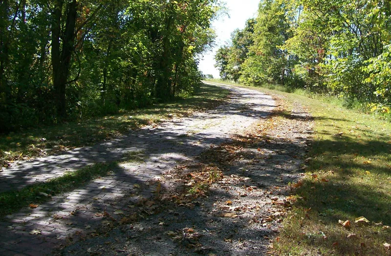
Peacock Road is a short stretch of brick-paved township road in Center Township, Guernsey County, Ohio, running about six-tenths of a mile near U.S. Route 40 between Cambridge and Old Washington. It follows part of the 1828 National Road right of way and keeps the hilly, curving character of the original route. In March 1918, federal and state officials called for the immediate paving of the unimproved stretch so trucks carrying war supplies could move east. Work began with fifty prison inmates from the Mansfield Reformatory, ninety horses and local stone from a nearby quarry. The brick was laid over a stone base with sand and mastic. A steep curve includes an unusual brick curb, and a 1925-style cable and plank guardrail remains. Asphalt added later has largely worn away. Compared with other wartime sections in the township, this one retains the most intact length of 1918 paving.
Significance in brief: The nomination argues the road served as an original National Road alignment and was rebuilt in 1918 as a World War I emergency truck route for the Federal government. Its 1918 brick paving, built with convict labor, survives with more intact length than other wartime sections in the township. A rare brick curb on a steep, sharp curve adds to its engineering interest.
Machine-generated summary. This summary was generated by a language model from the official nomination document and has not been reviewed line by line by an editor. It may contain errors. Check the source document before relying on any detail. Source: nomination document (PDF) · National Archives catalog entry. NRHP reference 85001842, listed August 23, 1985. Summary generated October 2026 (model claude-sonnet-5-5, prompt v1.0-2026-10-29, confidence high).
Key facts
| Address | Center Township Rd. 650, Cambridge |
|---|---|
| County | Guernsey County |
| Listed | August 23, 1985 |
| Reference number | 85001842 |
| Resource type | Structure |
| Period of significance | 1918 |
| Architect / builder | Harness Rennick, contractor (1918 reconstruction using Mansfield Reformatory convict labor) |
| Criteria |
|
| Areas of significance | Engineering, Transportation, Politics/Government |
| Level of significance | State |
| Status (as stated in the nomination) | Still in use as an access road for two farm homesteads and a township house; brick is worn, partly covered by crumbling asphalt, with one sunken section repaired with gravel. |
| Acreage | 0.9 |
| Coordinates | 40.02703, -81.50237 (NPS GIS) |
What listing means for this property
National Register listing is honorary: it recognises significance and does not restrict what a private owner may do without federal money or permits. It unlocks the 20% federal rehabilitation tax credit for income-producing buildings, state credits in many states, and Section 106 review when federal agencies are involved. See what listing means in practice.
General information, not legal or tax advice. Rules change; confirm with your State Historic Preservation Office or a qualified adviser.
Sources and further reading
- National Park Service, National Register of Historic Places database (snapshot May 2026), reference 85001842.
- Nomination form (PDF, National Archives) — catalog entry
- Wikipedia article (used for cross-checking only; text not reproduced here)
- Wikidata Q6978121
- This listing as JSON
Last updated October 2026. Found an error? See the editorial policy for how to report it.