Harmony Hill Dairy House
Also known as: General William Lytle Dairy House; Cle-638-8
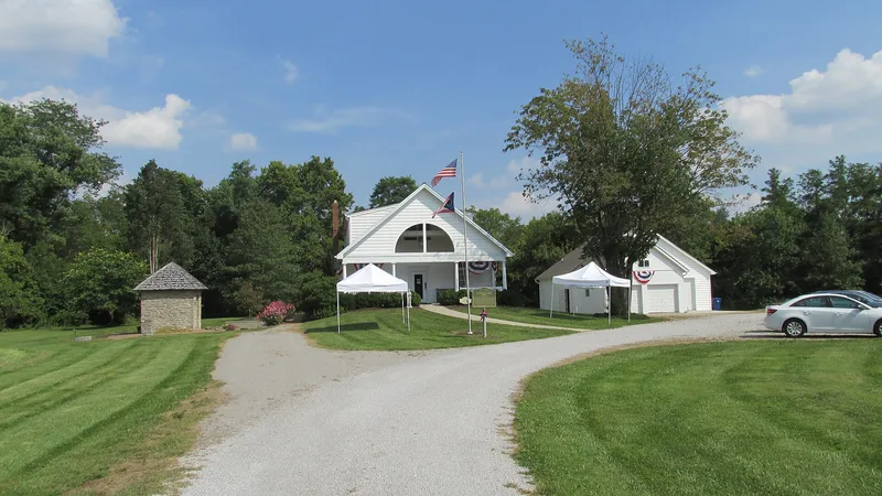

Why it's listed
Built around 1800, this tiny limestone dairy house sits on a low hill in Williamsburg, Ohio, about three blocks south of the town square. It measures just over ten feet on each side, with a pyramidal wood-shake roof, rubble limestone walls, a single west doorway and a stone slab floor. Beside it is a stone-lined well dating to the same years. The building was part of Harmony Hill, the home farm of General William Lytle, a surveyor and explorer who founded Williamsburg. His house and a government land office on the farm are gone, leaving the dairy as the only surviving structure. The stonemason John Charles is credited with building it. After decades of neglect, the roof collapsed in 1997, and restoration began the next year, using old photographs and drawings to replace missing parts. It is listed as the oldest surviving building in Clermont County and a rare example of early settlement architecture, likely reflecting a mid-Atlantic building type.
Significance in brief: The nomination argues the dairy house is an early and rare survivor of settlement-era architecture and is credited as the oldest surviving building in Clermont County and in Williamsburg. It is the only surviving building from Harmony Hill, home of William Lytle, founder of Williamsburg and called the 'father of Clermont County.' It represents the exploration and settlement of the Virginia Military District.
Machine-generated summary. This summary was generated by a language model from the official nomination document and has not been reviewed line by line by an editor. It may contain errors. Check the source document before relying on any detail. Source: nomination document (PDF) · National Archives catalog entry. NRHP reference 01000592, listed May 30, 2001. Summary generated October 2026 (model claude-sonnet-5-5, prompt v1.0-2026-10-29, confidence high).
Key facts
| Address | 299 S. Third St., Williamsburg |
|---|---|
| County | Clermont County |
| Listed | May 30, 2001 |
| Reference number | 01000592 |
| Resource type | Building |
| Period of significance | c. 1800-1809 |
| Architect / builder | Charles, John |
| Architectural style | no style |
| Criteria |
|
| Areas of significance | Exploration/Settlement |
| Level of significance | Local |
| Status (as stated in the nomination) | Restored beginning in 1998 after the roof collapsed and walls partly fell in 1997; some reconstruction was needed. It is now part of a small historical museum complex. |
| Acreage | 0.9 |
| Coordinates | 39.04966, -84.05857 (NPS GIS) |
What listing means for this property
National Register listing is honorary for a privately owned home: it does not by itself restrict what an owner may do with their own money, and it does not require public access. Restrictions come from local landmark or historic-district ordinances, which are separate (how they differ).
Owner-occupied houses are not eligible for the 20% federal rehabilitation tax credit, which applies to income-producing buildings, but many states offer credits for homeowners. Listing also opens the door to preservation easements and to buying a plaque. Start with what listing means for homeowners, renovating a listed house and selling one.
General information, not legal or tax advice. Rules change; confirm with your State Historic Preservation Office or a qualified adviser.
Sources and further reading
- National Park Service, National Register of Historic Places database (snapshot May 2026), reference 01000592.
- Nomination form (PDF, National Archives) — catalog entry
- Wikidata Q137613521
- This listing as JSON
Last updated October 2026. Found an error? See the editorial policy for how to report it.