Cascine (Boundary Increase)
Also known as: See Also:Cascine

Why it's listed
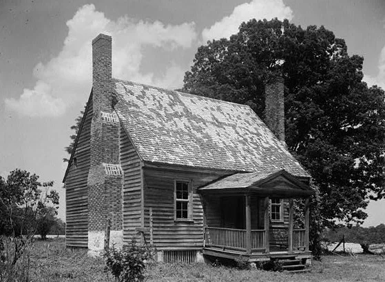
Cascine is a plantation of roughly 1500 acres near Louisburg, North Carolina, that has stayed in agricultural use since land grants to the Perry family in 1752 and 1763. The original 60-acre core holds a mid-18th-century frame house, a ca. 1850 Greek Revival main house, an office, a brick kitchen and farm outbuildings. This boundary amendment enlarges the listed area to 1287 acres to include the wider working landscape. Added resources include a mid-19th-century family gristmill on Cedar Creek with its race and stone dam, a miller's house, a probable slave cemetery, brick and artifact scatters that may mark slave cabins, tenant houses, and many log and frame tobacco barns. Together they show the move from slave labor to tenancy after the Civil War. The nomination argues that the unusually intact landscape and its archaeological potential make Cascine important for understanding southern plantation life.
Significance in brief: The nomination argues that Cascine is a rare, intact record of southern plantation history from the colonial era to the present. Its buildings, landscape and archaeological sites show the growth of a slave-labor plantation economy, the shift to farm tenancy after the Civil War, and continued agricultural use. It is also tied to the locally prominent Perry family and holds strong potential for archaeological study.
Machine-generated summary. This summary was generated by a language model from the official nomination document and has not been reviewed line by line by an editor. It may contain errors. Check the source document before relying on any detail. Source: nomination document (PDF) · National Archives catalog entry. NRHP reference 85003114, listed December 4, 1985. Summary generated October 2026 (model claude-sonnet-5-5, prompt v1.0-2026-10-29, confidence medium).
Key facts
| Address | N side of NC 1702, Louisburg |
|---|---|
| County | Franklin County |
| Listed | December 4, 1985 |
| Reference number | 85003114 |
| Resource type | District |
| Period of significance | 1850-1940 |
| Architectural style | Greek Revival and Georgian (plantation house, office and miller's house) |
| Criteria |
|
| Areas of significance | Agriculture, Architecture |
| Level of significance | State |
| Status (as stated in the nomination) | The farm is still worked, and the main house is occupied. Several outlying buildings are deteriorated or abandoned, and the mill's first-level floor has collapsed. |
| Acreage | 1227 |
| Coordinates | 36.04153, -78.32407 (NPS GIS) |
What listing means for this property
This is a historic district. Buildings within its boundary are either contributing (they add to the district's significance) or non-contributing. Owners of contributing income-producing buildings can claim the 20% federal rehabilitation tax credit; homeowners should look at state credits. National Register districts impose no design review by themselves; a local historic district ordinance, if one exists, does (the difference explained).
General information, not legal or tax advice. Rules change; confirm with your State Historic Preservation Office or a qualified adviser.
Sources and further reading
- National Park Service, National Register of Historic Places database (snapshot May 2026), reference 85003114.
- Nomination form (PDF, National Archives) — catalog entry
- Wikipedia article (used for cross-checking only; text not reproduced here)
- Wikidata Q18711543
- This listing as JSON
Last updated October 2026. Found an error? See the editorial policy for how to report it.