Erlanger Mill Village Historic District
Erlanger Mill Village Historic District is a historic district in Lexington, Davidson County, North Carolina, listed on the National Register of Historic Places on January 9, 2008 (reference number 07001371). The National Park Service records its significance in Industry, Community Planning and Development and Architecture at the local level.
Facts from the NPS National Register database (); nomination summary October 2026. Last updated . Sources for each fact.

The pin is a point inside the NPS boundary polygon, not a surveyed location.
Why it's listed
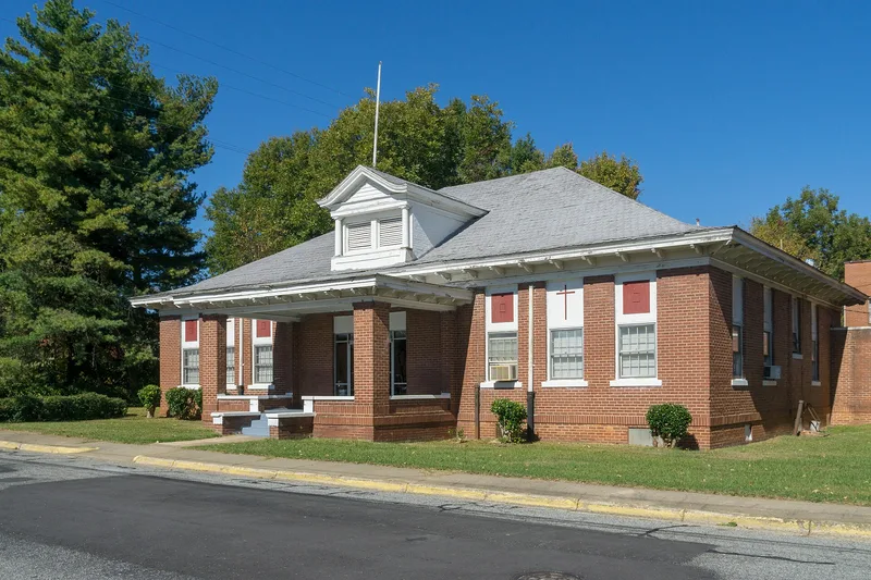
Erlanger Mill Village is a planned textile-worker neighborhood about one mile north of downtown Lexington, North Carolina. Covering roughly 85 acres, it was built mostly between 1913 and 1929 around the Erlanger Mill complex, and it is separated from the city by a four-lane highway. The streets follow a grid, with curved streets at the north end laid out by Charlotte landscape architect Earle S. Draper. Most of the housing is frame and one story tall, set close to the street. The earliest section, built out by 1916-17, has modest side-gable houses with shed-roofed porches. Later blocks, developed from 1917 to 1923, include Craftsman bungalows, and houses on Second Rainbow Street were the last built, between 1923 and 1929. The houses may have been assembled from Minter Homes kits. The district also has two Gothic Revival churches, a former school building and the mill office. Many houses now have replacement siding, but most keep their original form. Some mill-related recreation grounds were lost to commercial development.
Significance in brief: The excerpt provided covers only the description. It presents the village as a remarkably intact planned mill community with early basic house types and later, stylish Craftsman bungalows. The statement of significance and the criteria boxes are not included in the text, so the specific arguments for listing are not available.
Machine-generated summary. This summary was generated by a language model from the official nomination document and has not been reviewed line by line by an editor. It may contain errors. Check the source document before relying on any detail. Source: nomination document (PDF) · National Archives catalog entry. NRHP reference 07001371, listed January 9, 2008. Summary generated October 2026 (model claude-sonnet-5-5, prompt v1.0-2026-10-29, confidence medium).
Key facts
| Official database NPS National Register database, ref. 07001371 , checked | |
|---|---|
| Address | Roughly bounded by Winston Rd., Short, 7th, Hames, Second Rainbow, Park Circle, & Olympia Sts., Lexington |
| County | Davidson County |
| Listed | January 9, 2008 |
| Reference number | 07001371 |
| Resource type | District |
| Areas of significance | Industry, Community Planning and Development, Architecture |
| Level of significance | Local |
| National Historic Landmark | No |
| Acreage | 85 |
| Official document, machine-extracted Nomination form (National Archives) , checked | |
| Architect / builder | Earle S. Draper, Charlotte landscape architect, laid out the crescent-shaped First and Second Rainbow Streets; houses may have been built from Minter Homes Company kits |
| Architectural style | Bungalow/Craftsman; Gothic Revival; No Style |
| Status (as stated in the nomination) | Primarily residential, with the mill complex, two churches and former school buildings still present. Many houses have been altered since becoming privately owned after 1953, but most keep their original form. |
| Official dataset NPS cultural-resource GIS (NRHP locations) | |
| Coordinates | 35.84088, -80.25635 |
What listing means for this property
This is a historic district. Buildings within its boundary are either contributing (they add to the district's significance) or non-contributing. Owners of contributing income-producing buildings can claim the 20% federal rehabilitation tax credit; homeowners should look at state credits. National Register districts impose no design review by themselves; a local historic district ordinance, if one exists, does (the difference explained).
General information, not legal or tax advice. Rules change; confirm with your State Historic Preservation Office or a qualified adviser.
Questions about Erlanger Mill Village Historic District
When was Erlanger Mill Village Historic District added to the National Register of Historic Places?
Erlanger Mill Village Historic District was listed on January 9, 2008. Its National Register reference number is 07001371.
Is Erlanger Mill Village Historic District a National Historic Landmark?
No. The National Park Service database (snapshot of May 2026) lists Erlanger Mill Village Historic District on the National Register but does not record it as a National Historic Landmark.
Where is Erlanger Mill Village Historic District?
Roughly bounded by Winston Rd., Short, 7th, Hames, Second Rainbow, Park Circle, & Olympia Sts., Lexington, Davidson County, North Carolina; coordinates 35.84088, -80.25635.
Why is Erlanger Mill Village Historic District historically significant?
According to a machine-generated summary of its nomination form: The excerpt provided covers only the description. It presents the village as a remarkably intact planned mill community with early basic house types and later, stylish Craftsman bungalows. The statement of significance and the criteria boxes are not included in the text, so the specific arguments for listing are not available. Check the nomination document before relying on any detail.
Who designed or built Erlanger Mill Village Historic District?
The nomination form names Earle S. Draper, Charlotte landscape architect, laid out the crescent-shaped First and Second Rainbow Streets; houses may have been built from Minter Homes Company kits as architect or builder (extracted by machine from the nomination; check the source document).
Where can I read the original nomination for Erlanger Mill Village Historic District?
The nomination form is a public record held by the National Archives: nomination document (PDF).
Sources and further reading
- National Park Service, National Register of Historic Places database (snapshot May 2026), reference 07001371.
- Nomination form (PDF, National Archives) — catalog entry
- Wikipedia article (used for cross-checking only; text not reproduced here)
- Wikidata Q18353888
- This listing as JSON
Last updated November 2026. Found an error? See the editorial policy for how to report it.