Ward, Dr. E. H., Farm

Why it's listed
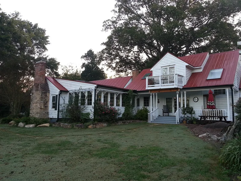
Set on a small knoll off SR 1700 near Bynum, this Chatham County farmstead grew around a log cabin that Dr. E. H. Ward, a country physician, moved to the site about 1850. Ward added a weatherboard front section around 1870, covering the older log portion with matching siding, and a board-and-batten rear ell followed about 1900. Outbuildings include a one-room doctor's office, a carriage house, a barn, log cribs, a smokehouse with a log pen, and a brick well house. Ward practiced medicine and farmed, and by his death in 1896 his holdings had grown to 344 acres. The property was nominated as a representative small central North Carolina farmstead of the nineteenth century, as a place associated with an early local physician, and as an example of vernacular building techniques, such as iron spikes set into porch post bases to slow rot. Descendants of Ward continued to occupy the house.
Significance in brief: The farm is presented as typical of small Chatham County farmsteads developed in the later nineteenth century. It is tied to Dr. E. H. Ward, an early physician in eastern Chatham County who combined medicine with farming. The house and outbuildings also show vernacular building traditions of rural central North Carolina.
Machine-generated summary. This summary was generated by a language model from the official nomination document and has not been reviewed line by line by an editor. It may contain errors. Check the source document before relying on any detail. Source: nomination document (PDF) · National Archives catalog entry. NRHP reference 85001461, listed July 5, 1985. Summary generated October 2026 (model claude-sonnet-5-5, prompt v1.0-2026-10-29, confidence high).
Key facts
| Address | SR 1700, Bynum |
|---|---|
| County | Chatham County |
| Listed | July 5, 1985 |
| Reference number | 85001461 |
| Resource type | Building |
| Architect / builder | Unknown |
| Criteria |
|
| Areas of significance | Agriculture, Health/Medicine, Architecture |
| Level of significance | Local |
| Status (as stated in the nomination) | Described as occupied private residence and agricultural property; the grounds around the main house are overgrown. |
| Acreage | 48.5 |
| Coordinates | 35.77841, -79.09602 (NPS GIS) |
What listing means for this property
National Register listing is honorary for a privately owned home: it does not by itself restrict what an owner may do with their own money, and it does not require public access. Restrictions come from local landmark or historic-district ordinances, which are separate (how they differ).
Owner-occupied houses are not eligible for the 20% federal rehabilitation tax credit, which applies to income-producing buildings, but many states offer credits for homeowners. Listing also opens the door to preservation easements and to buying a plaque. Start with what listing means for homeowners, renovating a listed house and selling one.
General information, not legal or tax advice. Rules change; confirm with your State Historic Preservation Office or a qualified adviser.
Sources and further reading
- National Park Service, National Register of Historic Places database (snapshot May 2026), reference 85001461.
- Nomination form (PDF, National Archives) — catalog entry
- Wikipedia article (used for cross-checking only; text not reproduced here)
- Wikidata Q18159128
- This listing as JSON
Last updated October 2026. Found an error? See the editorial policy for how to report it.