Hankins Stone Arch Bridge

Why it's listed
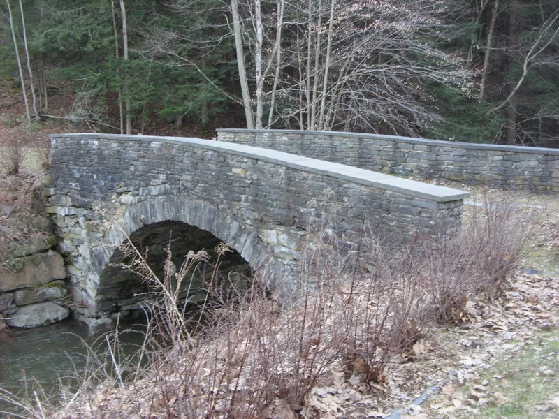
Spanning Hankins Creek in a small hamlet on the Upper Delaware River, this stone arch bridge was built in 1905 by quarryman and mason John Inman. It is about 40 feet long with a roadway roughly 15 feet wide, a single round arch of mortared, partly dressed voussoirs, fieldstone spandrels and parapets, and bluestone coping. Inman was hired to build a road with arch bridges across Basket Creek and Hankins Creek, linking Hankins to Long Eddy, which topography and a rocky point had long kept isolated. The Basket Creek bridge was later bypassed and largely washed away in the 1942 flood, leaving Hankins as one of only two traditional stone arch bridges in the 74-mile river corridor. The bridge carried East Ridge Road until the road was rerouted in 1973. Local citizens pushed for its preservation, and the county stabilized the creek bank in 1999. It is listed for its engineering and its role in the community's development.
Significance in brief: The nomination argues it is a rare, intact example of traditional stone arch bridge construction, one of only two remaining in the 74-mile Upper Delaware corridor (Criterion C). It also shows how the road network developed in Hankins when the hamlet was a center of industry and recreation (Criterion A).
Machine-generated summary. This summary was generated by a language model from the official nomination document and has not been reviewed line by line by an editor. It may contain errors. Check the source document before relying on any detail. Source: nomination document (PDF) · National Archives catalog entry. NRHP reference 00000838, listed July 27, 2000. Summary generated October 2026 (model claude-sonnet-5-5, prompt v1.0-2026-10-29, confidence high).
Key facts
| Address | Sullivean Cty. Rd. 94, E., Hankins |
|---|---|
| County | Sullivan County |
| Listed | July 27, 2000 |
| Reference number | 00000838 |
| Resource type | Structure |
| Period of significance | 1905 |
| Architect / builder | John Inman, builder |
| Architectural style | OTHER / stone arch bridge |
| Criteria |
|
| Areas of significance | Engineering, Transportation, Community Planning and Development |
| Level of significance | Local |
| Status (as stated in the nomination) | Closed to vehicle traffic since 1973 and maintained for pedestrian use and passive recreation by Sullivan County and the Town of Fremont; wingwalls were rebuilt in 1999 to stabilize the banks. |
| Acreage | 0.9 |
| Coordinates | 41.81651, -75.09154 (NPS GIS) |
What listing means for this property
For a publicly owned building or structure, listing mainly matters when federal funds, permits or licences are involved: projects then go through Section 106 review so effects on the property are considered. Listing also strengthens applications for preservation grants and, for leased income-producing uses, can enable the federal rehabilitation tax credit.
General information, not legal or tax advice. Rules change; confirm with your State Historic Preservation Office or a qualified adviser.
Sources and further reading
- National Park Service, National Register of Historic Places database (snapshot May 2026), reference 00000838.
- Nomination form (PDF, National Archives) — catalog entry
- Wikipedia article (used for cross-checking only; text not reproduced here)
- Wikidata Q5648543
- This listing as JSON
Last updated October 2026. Found an error? See the editorial policy for how to report it.