Sag Harbor Village District (Boundary Increase)

Why it's listed
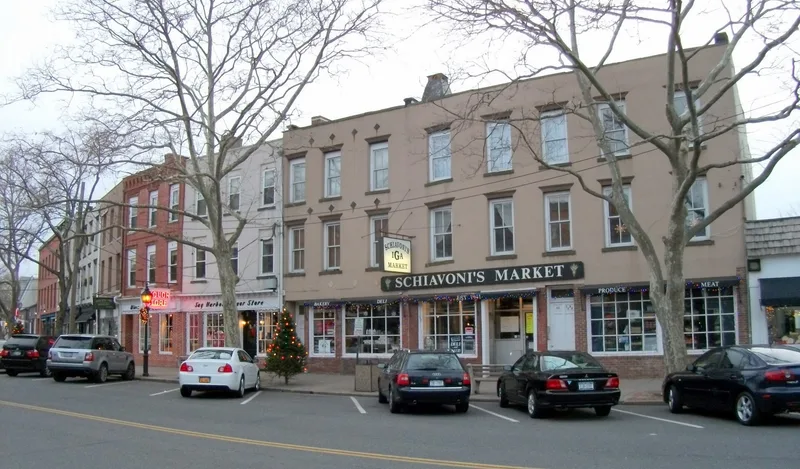
Sag Harbor's historic district covers the older core of a port village on Long Island's South Fork. It enlarges a district first listed in 1973, adding about 35 percent more land after a 1990-91 village survey. The district contains nearly 900 resources, mostly freestanding wood-frame houses one to three stories high, built from the late eighteenth to the mid-twentieth century, along with commercial blocks on Main Street, four cemeteries and two large parks. Lots were first laid out in 1745 south of the Long Wharf, and the 'Y'-shaped road pattern survives. Development followed whaling in the early nineteenth century, factory work such as the Fahys watchcase factory, and later resort building, including Queen Anne cottages on Palmer Terrace. The district also includes Eastville, a nineteenth century African American and Native American community. Boundaries exclude areas dominated by post-World War II construction or heavy alteration.
Significance in brief: The district preserves a village whose street pattern dates to 1745 and whose housing stock spans the late eighteenth to mid-twentieth centuries, from the whaling era through factory and resort development. It also includes Eastville, described as a unique nineteenth century African American and Native American community. The expansion was based on a 1990-91 survey that identified many more eligible buildings.
Machine-generated summary. This summary was generated by a language model from the official nomination document and has not been reviewed line by line by an editor. It may contain errors. Check the source document before relying on any detail. Source: nomination document (PDF) · National Archives catalog entry. NRHP reference 94000400, listed May 10, 1994. Summary generated October 2026 (model claude-sonnet-5-5, prompt v1.0-2026-10-29, confidence medium).
Key facts
| Address | Roughly bounded by Sag Harbor, Bay, Eastville, Grand, Joel'sLn., Middle Line Hwy., Main, Glover and Long Island, Sag Harbor |
|---|---|
| County | Suffolk County |
| Listed | May 10, 1994 |
| Reference number | 94000400 |
| Resource type | District |
| Architect / builder | Augustus N. Allen (John Jermain Memorial Library, 1910); R. Guastavino Co. (library dome) |
| Architectural style | Georgian, Federal, Greek Revival, Gothic Revival, Italianate, Queen Anne, Folk Victorian, Colonial Revival |
| Areas of significance | Architecture, Commerce, Maritime History, European, Industry, Invention, Entertainment/Recreation, Literature |
| Level of significance | State |
| Status (as stated in the nomination) | Largely built up; the village retains its harbor orientation and early street patterns, and many buildings remain in residential, commercial and civic use. |
| Acreage | 2 |
| Within district | Sag Harbor Village District |
| Coordinates | 40.99349, -72.28707 (NPS GIS) |
What listing means for this property
This is a historic district. Buildings within its boundary are either contributing (they add to the district's significance) or non-contributing. Owners of contributing income-producing buildings can claim the 20% federal rehabilitation tax credit; homeowners should look at state credits. National Register districts impose no design review by themselves; a local historic district ordinance, if one exists, does (the difference explained).
General information, not legal or tax advice. Rules change; confirm with your State Historic Preservation Office or a qualified adviser.
Sources and further reading
- National Park Service, National Register of Historic Places database (snapshot May 2026), reference 94000400.
- Nomination form (PDF, National Archives) — catalog entry
- Wikipedia article (used for cross-checking only; text not reproduced here)
- Wikidata Q7398869
- This listing as JSON
Last updated October 2026. Found an error? See the editorial policy for how to report it.