Plum Island Light Station
Also known as: Plum Gut light

Why it's listed
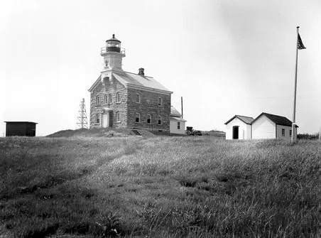
Plum Island Light Station occupies about three acres at the northwest tip of Plum Island, overlooking Plum Gut, the channel between the island and Long Island's North Fork. Its centerpiece is a two-story, rock-faced pink granite lighthouse of 1869 with a cast iron tower rising from the front gable and bearing the date in iron numerals. A c.1900 brick oil house and a c.1920 wood storage shed also survive. The lighthouse was one of six built around Long Island Sound to a standard fourth order plan of the Third Light-House District, and it remained staffed until 1978. It replaced an 1827 stone tower and keeper's dwelling. The station is recognized for its architecture and for its place in the federal system of navigation aids guarding the eastern entrances to Long Island Sound. The lens was removed in 1994, interior surfaces are deteriorated, and the property is no longer in active use.
Significance in brief: The station is argued to be significant under Criterion A for maritime history, as a local example of federal responsibility for safe navigation at the eastern entrance to Long Island Sound. Under Criterion C it is a state-level example of the Third Light-House District's standard plan for a fourth order lighthouse, one of six built to that design.
Machine-generated summary. This summary was generated by a language model from the official nomination document and has not been reviewed line by line by an editor. It may contain errors. Check the source document before relying on any detail. Source: nomination document (PDF) · National Archives catalog entry. NRHP reference 11000014, listed February 11, 2011. Summary generated October 2026 (model claude-sonnet-5-5, prompt v1.0-2026-10-29, confidence medium).
Key facts
| Address | N.W. corner of Plum Island, Orient Point |
|---|---|
| County | Suffolk County |
| Listed | February 11, 2011 |
| Reference number | 11000014 |
| Resource type | Building |
| Period of significance | 1869-1960 |
| Architectural style | Romanesque (form classification); the narrative describes the design as Italianate |
| Criteria |
|
| Areas of significance | Architecture, Maritime History |
| Level of significance | State |
| Status (as stated in the nomination) | The lighthouse is inactive and the property is vacant or not in use. Interior finishes are deteriorated from lack of heat and water infiltration. The Fresnel lens and clockwork were removed in 1994. |
| Acreage | 3 |
| Coordinates | 41.17990, -72.20590 (NPS GIS) |
What listing means for this property
For a publicly owned building or structure, listing mainly matters when federal funds, permits or licences are involved: projects then go through Section 106 review so effects on the property are considered. Listing also strengthens applications for preservation grants and, for leased income-producing uses, can enable the federal rehabilitation tax credit.
Noted as vacant in the nomination. Nomination documents can be decades old; current status may differ. If you are considering buying an empty listed property, read the due-diligence checklist.
General information, not legal or tax advice. Rules change; confirm with your State Historic Preservation Office or a qualified adviser.
Sources and further reading
- National Park Service, National Register of Historic Places database (snapshot May 2026), reference 11000014.
- Nomination form (PDF, National Archives) — catalog entry
- Wikipedia article (used for cross-checking only; text not reproduced here)
- Wikidata Q7205330
- This listing as JSON
Last updated October 2026. Found an error? See the editorial policy for how to report it.