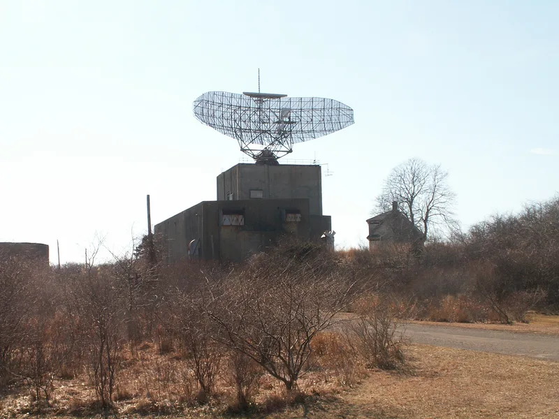
AN/FPS-35 Radar Tower and Antenna

Why it's listed
Rising on a sandy rise near Montauk Point at the eastern end of Long Island, this Cold War radar installation pairs an 85-foot poured concrete tower with a 70-ton steel antenna about 126 feet wide. The tower, square in plan with a checkerboard pattern of cast ribs, housed equipment and duty personnel across five levels. The AN/FPS-35 entered service in December 1960 at the Montauk Air Force Station, formerly the World War II Army post Camp Hero. It was the first production unit of its type and had an effective range of 200 to 250 miles, extending warning of bomber attack far over the Atlantic. It also fed data to civilian air traffic control. The station closed in 1981 when a new radar near Riverhead took over, and the equipment was abandoned in place. Vandalism stripped much of the interior and the antenna is corroded, but the tower remains sound. It is described as the last intact example of its class, which supports its national significance.
Significance in brief: The facility represents the air defense posture of the United States on the eastern seaboard during the Cold War. The Montauk unit was the first production AN/FPS-35 deployed and is described as the last intact example of the 12 units activated. It is nominated at the national level under military history and engineering.
Machine-generated summary. This summary was generated by a language model from the official nomination document and has not been reviewed line by line by an editor. It may contain errors. Check the source document before relying on any detail. Source: nomination document (PDF) · National Archives catalog entry. NRHP reference 02000615, listed June 4, 2002. Summary generated October 2026 (model claude-sonnet-5-5, prompt v1.0-2026-10-29, confidence high).
Key facts
| Address | Montauk Point State Parkway, Montauk |
|---|---|
| County | Suffolk County |
| Listed | June 4, 2002 |
| Reference number | 02000615 |
| Resource type | Building |
| Period of significance | 1960 |
| Architect / builder | unknown |
| Architectural style | OTHER: Radar Tower and Antenna |
| Criteria |
|
| Areas of significance | Military, Engineering |
| Level of significance | National |
| Status (as stated in the nomination) | Radar no longer functional; antenna intact but heavily corroded, internal equipment vandalized, concrete tower in sound condition; abandoned in place after 1981 deactivation. |
| Acreage | 0.9 |
| Coordinates | 41.06264, -71.87402 (NPS GIS) |
What listing means for this property
National Register listing is honorary: it recognises significance and does not restrict what a private owner may do without federal money or permits. It unlocks the 20% federal rehabilitation tax credit for income-producing buildings, state credits in many states, and Section 106 review when federal agencies are involved. See what listing means in practice.
Noted as vacant in the nomination. Nomination documents can be decades old; current status may differ. If you are considering buying an empty listed property, read the due-diligence checklist.
General information, not legal or tax advice. Rules change; confirm with your State Historic Preservation Office or a qualified adviser.
Sources and further reading
- National Park Service, National Register of Historic Places database (snapshot May 2026), reference 02000615.
- Nomination form (PDF, National Archives) — catalog entry
- Wikipedia article (used for cross-checking only; text not reproduced here)
- Wikidata Q1698421
- This listing as JSON
Last updated October 2026. Found an error? See the editorial policy for how to report it.