West Bank Light Station
Also known as: West Bank Range Front Light; West Bank Light

Why it's listed
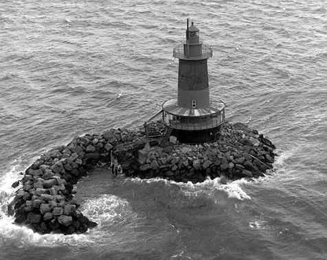
West Bank Light Station is an offshore lighthouse standing in about 21 feet of water in Lower New York Bay, roughly 3.3 miles east of New Dorp Beach on Staten Island. Built in 1901 and made two stories taller in 1908, it has a cast iron caisson foundation 33 feet across, filled with concrete and ringed by riprap, with a conical iron tower above it. A watch room and lantern crown the structure. Its profile fits the "spark plug" lighthouse type. It serves as the front light of a range marking part of the Ambrose Channel and is paired with the Staten Island Range Rear Light. Records describe keepers and assistants who lived in isolation on the station, a fog signal added in 1901, and an early trial of incandescent oil vapor lamps in 1904. The light is now automated, powered by solar panels, and owned by the Coast Guard. The tower still looks much as it did after 1908, though its original gallery awning has been removed.
Significance in brief: The nomination presents it as a surviving example of the spark plug lighthouse type, serving as the front light of a range marking part of the Ambrose Channel. It also documents the Lighthouse Service's keeper life and equipment testing at the station, including early incandescent oil vapor lamps, plus the 1908 heightening.
Machine-generated summary. This summary was generated by a language model from the official nomination document and has not been reviewed line by line by an editor. It may contain errors. Check the source document before relying on any detail. Source: nomination document (PDF) · National Archives catalog entry. NRHP reference 06001230, listed January 9, 2007. Summary generated October 2026 (model claude-sonnet-5-5, prompt v1.0-2026-10-29, confidence medium).
Key facts
| Address | In lower New York Bay, 3.3 mi. E of New Dorp Beach, New Dorp Beach |
|---|---|
| County | Staten Island |
| Listed | January 9, 2007 |
| Reference number | 06001230 |
| Resource type | Building |
| Architectural style | No Style |
| Areas of significance | Maritime History, Transportation, Architecture, Engineering |
| Level of significance | Local |
| Status (as stated in the nomination) | Owned by the U.S. Coast Guard and operated as an automated aid to navigation; reached only by boat. Interior paint is flaking and some fittings are in poor condition. |
| Acreage | 0.1 |
| Coordinates | 40.53809, -74.04267 (NPS GIS) |
What listing means for this property
For a publicly owned building or structure, listing mainly matters when federal funds, permits or licences are involved: projects then go through Section 106 review so effects on the property are considered. Listing also strengthens applications for preservation grants and, for leased income-producing uses, can enable the federal rehabilitation tax credit.
General information, not legal or tax advice. Rules change; confirm with your State Historic Preservation Office or a qualified adviser.
Sources and further reading
- National Park Service, National Register of Historic Places database (snapshot May 2026), reference 06001230.
- Nomination form (PDF, National Archives) — catalog entry
- Wikipedia article (used for cross-checking only; text not reproduced here)
- Wikidata Q1581328
- This listing as JSON
Last updated October 2026. Found an error? See the editorial policy for how to report it.