Fort Tompkins Quadrangle
Also known as: Ft. Tompkins

Why it's listed
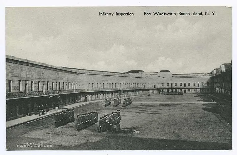
Fort Tompkins Quadrangle is a large stone fortification on the highest point of the west side of the Narrows at Fort Wadsworth, Staten Island. Begun in 1847 and completed in August 1861, it was built as a fortified barracks supporting Battery Weed and two other batteries, Morton and Hudson. The irregular quadrangle measures roughly 500 by 250 feet and is built of granite and brick with earthen roofs. The front wall holds eighteen open arched rooms behind two arched entryways, while the other walls form a channeled moat lined with gun ports, cells and powder magazines. Its site has been fortified since the Dutch built a blockhouse in 1663, and later served British and American forces. The exterior remains much as built, though the front arches were bricked in and the interior rooms were adapted for offices. The fort is recognized as a leading example of mid-nineteenth-century stone coastal defense and as a key military landmark.
Significance in brief: The nomination argues it is a prime example of the 'era of stone fortifications' in military architecture. It also stands on a site fortified since 1663 and, with Battery Weed, is part of what is described as the oldest active permanently occupied military post in the United States.
Machine-generated summary. This summary was generated by a language model from the official nomination document and has not been reviewed line by line by an editor. It may contain errors. Check the source document before relying on any detail. Source: nomination document (PDF) · National Archives catalog entry. NRHP reference 74001300, listed July 30, 1974. Summary generated October 2026 (model claude-sonnet-5-5, prompt v1.0-2026-10-29, confidence medium).
Key facts
| Address | Building 137, Fort Wadsworth, New York |
|---|---|
| County | Staten Island |
| Listed | July 30, 1974 |
| Reference number | 74001300 |
| Resource type | Building |
| Period of significance | 1847-1861 |
| Architectural style | Era of stone fortifications |
| Areas of significance | Other, Military, Architecture |
| Level of significance | Local |
| Status (as stated in the nomination) | Described as in good condition, altered, and occupied; used for military administrative offices and as a museum. Exterior largely unchanged apart from brick-enclosed arched openings in the front wall. |
| Acreage | 3 |
| Coordinates | 40.50566, -74.06071 (NPS GIS) |
What listing means for this property
National Register listing is honorary: it recognises significance and does not restrict what a private owner may do without federal money or permits. It unlocks the 20% federal rehabilitation tax credit for income-producing buildings, state credits in many states, and Section 106 review when federal agencies are involved. See what listing means in practice.
General information, not legal or tax advice. Rules change; confirm with your State Historic Preservation Office or a qualified adviser.
Sources and further reading
- National Park Service, National Register of Historic Places database (snapshot May 2026), reference 74001300.
- Nomination form (PDF, National Archives) — catalog entry
- Wikipedia article (used for cross-checking only; text not reproduced here)
- Wikidata Q1438763
- This listing as JSON
Last updated October 2026. Found an error? See the editorial policy for how to report it.