Colden Family Cemetery

Why it's listed
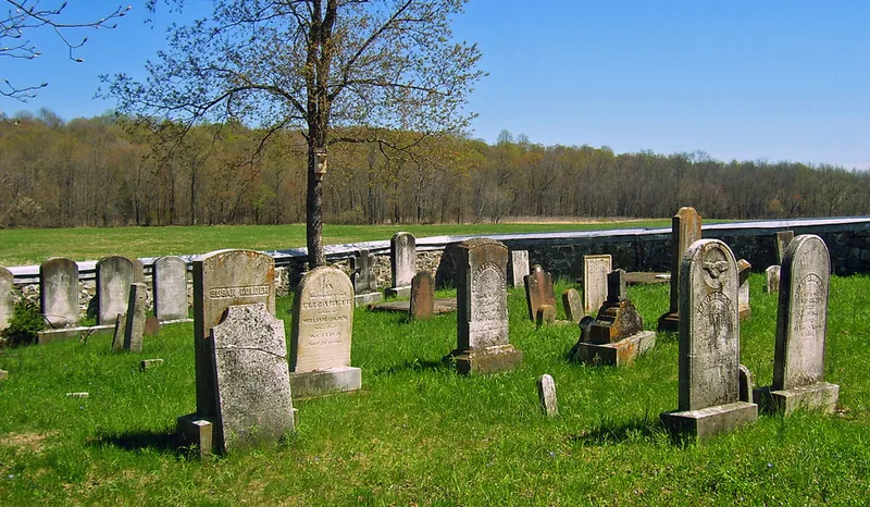
Set on a slight rise east of Maple Avenue in Montgomery, Orange County, this small family burial ground measures roughly 70 feet square and is enclosed by a chest-high wall of uncoursed bluestone laid in lime mortar. Cadwallader Colden, Sr., a Loyalist statesman and acting governor of colonial New York, established it around 1730 for family members and enslaved people. Several generations are buried here, including Cadwallader Colden II and his wife Elizabeth Ellison Colden, as well as John Fell, a New Jersey judge and delegate to the Continental Congress. The elder Colden is buried on Long Island but is honored with a memorial tablet. The gravestones include eighteenth-century three-lobed markers, flat tablets over stone-lined crypts, and varied nineteenth-century stones with willow and urn motifs. Small uninscribed stones likely mark the graves of slaves and children. The site was recognized for its link to a influential colonial family and for its funerary art, though overgrowth and toppled markers reflect deferred maintenance.
Significance in brief: The nomination argues the cemetery is significant for its association with the prominent Colden family, who held political, social and economic influence in colonial New York and the Montgomery-Newburgh region. It is also significant for its collection of eighteenth and nineteenth century grave markers that show changing tastes in funerary art.
Machine-generated summary. This summary was generated by a language model from the official nomination document and has not been reviewed line by line by an editor. It may contain errors. Check the source document before relying on any detail. Source: nomination document (PDF) · National Archives catalog entry. NRHP reference 05000017, listed February 9, 2005. Summary generated October 2026 (model claude-sonnet-5-5, prompt v1.0-2026-10-29, confidence high).
Key facts
| Address | Off of Maple Ave., Montgomery |
|---|---|
| County | Orange County |
| Listed | February 9, 2005 |
| Reference number | 05000017 |
| Resource type | Site |
| Period of significance | c. 1730-1910 |
| Criteria |
|
| Areas of significance | Art, Exploration/Settlement |
| Level of significance | Local |
| Status (as stated in the nomination) | Deferred maintenance has led to significant overgrowth within the walls and the toppling of some grave markers; the wall has a sheet metal cap to protect it from water infiltration. |
| Acreage | 0.9 |
| Coordinates | 41.52141, -74.14542 (NPS GIS) |
What listing means for this property
Sites (archaeological sites, battlefields, landscapes) are often listed with a restricted address to protect them from looting or disturbance. Listing is honorary for private owners; federal undertakings on or near the site go through Section 106 review, and state laws may protect burials and artefacts regardless of listing.
General information, not legal or tax advice. Rules change; confirm with your State Historic Preservation Office or a qualified adviser.
Sources and further reading
- National Park Service, National Register of Historic Places database (snapshot May 2026), reference 05000017.
- Nomination form (PDF, National Archives) — catalog entry
- Wikipedia article (used for cross-checking only; text not reproduced here)
- Wikidata Q5142505
- This listing as JSON
Last updated October 2026. Found an error? See the editorial policy for how to report it.